Watch how the community based GRASS GIS 6.4 software development evolved! You can see how the individual contributors modify and expand the source code – click screenshot for Youtube video:

GRASS GIS 6.4 development visualization from 1999 to 2013 (with soundtrack)

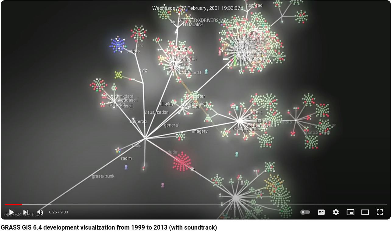
  • Dec 29, 1999: GRASS GIS 5.0 is being stored in an online source code repository in December 1999…
  • Dec 02, 2000: The developers work on all parts of the code…
  • Jan 15, 2002: Working on the future GRASS GIS 5.1 release
  • Nov 25, 2002: Starting GRASS 5.1 development with code restructuring
  • Jun 14, 2004: GRASS GIS 5.7 released in June 2004
  • Nov 09, 2004: Source code restructuring to get a better directory layout (all other developers waiting…)
  • Nov 09, 2004: … thousands of files are modified in this operation …
  • Nov 10, 2004: All developers resume their activities after the restructuring
  • Jan 10, 2005: Preparing the GRASS GIS 6.0.0 release…
  • Apr 09, 2005: GRASS GIS 6.0.0 published, release branch being split off from trunk for easier maintenance
  • Feb 22, 2006: Release of GRASS GIS 6.0.2 and new source code refactoring startedApr 05, 2006: Heavy development activity in trunk (development branch) …
  • Oct 25, 2006: GRASS GIS 6.2.0 released in October 2006
  • Apr 10, 2007: Preparing the GRASS GIS 6.2.2 release…
  • Jun 16, 2007: GRASS GIS 6.2.2 released in June 2007
  • Nov 01, 2007: Raster and vector modules being actively maintained…
  • Apr 02, 2007: New graphical user interface development speeding up (wxGUI)
  • Feb 20, 2008: Copyright statements prettified in many files
  • May 31, 2008: New GRASS 6 development branch being split off from trunk (which becomes GRASS 7)
  • Jun 10, 2008: Developers moving over to new branch
  • Feb 23, 2009: GRASS 6.4 release branch split off from GRASS 6 development branch
  • Apr 03, 2009: GRASS GIS 6.4 preparations starting…
  • Feb 24, 2010: Intense maintenance in GRASS 6.4 release branch
  • Sep 15, 2010: GRASS GIS 6.4.0 released in September 2010
  • Apr 12, 2011: GRASS GIS 6.4.1 released in April 2011
  • Jun 27, 2011: GRASS GIS 6.4.svn matures for the upcoming 6.4.2 release
  • Aug 16, 2011: Intense maintenance in GRASS 6.4 release branch (GRASS GIS 7 development not shown here)…
  • Feb 19, 2012: GRASS GIS 6.4.2 released in February 2012
  • Nov 13, 2012: Backporting graphical user interface bugfixes from GRASS GIS 7 to GRASS GIS 6.4
  • Apr 17, 2013: Further maintenance in GRASS 6.4 release branch
  • Jul 10, 2013: Fixing odds ‘n ends for the new stable release
  • Jul 27, 2013: GRASS GIS 6.4.3 released in July 2013

The corresponding timeline is also available at
https://grass.osgeo.org/home/history/releases/

THANKS TO ALL CONTRIBUTORS!
https://grass.osgeo.org/development/

Rendering: Markus Neteler
Audio track editing: Duccio Rocchini & Antonio Galea

Music:
Le bruit peut rendre sourd – Track 6/18 Album “Sensation electronique” by Saelynh (CC-BY-NC-ND) https://www.jamendo.com/en/track/1236/le-bruit-peut-rendre-sourd

Software used:
Gource software: https://code.google.com/p/gource/ (GPL)
OpenShot video editor: https://www.openshotvideo.com/ (GPL

Inspired by Vaclav Petras posting about “Did you know that you can see streets of downtown Raleigh in elevation data from NC sample dataset?” I wanted to try the new GRASS GIS 7 Addon r.shaded.pca which creates shades from various directions and combines then into RGB composites just to see what happens when using the new EU-DEM at 25m.

To warm up, I registered the “normally” shaded DEM (previously generated with gdaldem) with r.external in a GRASS GIS 7 location (EPSG 3035, LAEA) and overlayed the OpenStreetMap layer using WMS with GRASS 7’s r.in.wms. An easy task thanks to University of Heidelberg’s www.osm-wms.de. Indeed, they offer a similar shading via WMS, however, in the screenshot below you see the new EU data being used for controlling the light on our own:

OpenStreetMap shaded with EU DEM 25m

OpenStreetMap shaded with EU DEM 25m (click to enlarge)

Next item: trying r.shaded.pca… It supports multi-core calculation and the possibility to strengthen the effects through z-rescaling. In my example, I used:

r.shaded.pca input=eu_dem_25 output=eu_dem_25_shaded_pca nproc=3 zmult=50

The leads to a colorized hillshading map, again with the OSM data on top (50% transparency):

eu_dem_25m_PCA_shaded_OSM_trento_rovereto_garda_lake

OpenStreetMap shaded with r.shaded.pca using EU DEM 25m (click to enlarge)

Yes, fun – I like it :-)

Data sources:

eu_dem_upper_garda_lake_riva_arco_italy

EU DEM 25m upper Garda Lake area with Riva del Garda and Arco (Italy). 3D view in wxNVIZ – GRASS GIS 7

The 25m European Digital Elevation Model (EU-DEM, Version 1) is a Digital Surface Model (DSM) representing the first surface as illuminated by the sensors:

eu_dem_s_michele_rotaliana_italy

EU DEM Rotaliana with Mezzocorona and S. Michele (Italy). Produced using Copernicus data and information funded by the European Union – EU-DEM layers.

Its elevations were captured at 1 arc second postings (2.78E-4 degrees). The tiles are provided at 25m resolution in EU-LAEA (EPSG. 3035) projection, temporal coverage: 2000, published in Oct 2013. It is a realisation of the Copernicus programme, managed by the European Commission, DG Enterprise and Industry. Metadata are provided here. According to their “Methodology” page it is a hybrid product based on SRTM and ASTER GDEM data fused by a weighted averaging approach and it has been generated as a contiguous dataset divided into 1 degree by 1 degree tiles, corresponding to the SRTM naming convention. In addition to the DEM data, a colour shaded relief image over Europe is provided.

From the metadata page: “The EU-DEM data are provided as is, i.e. without a formal validation yet. An independent statistical validation is scheduled as part of the GIO land monitoring service activities, and will be made available in the course of 2014.

Data download

Note that the GeoTIFF files are of major size, up to 5 GB:

Data import

The data come as ZIP compressed files, hence unzipping occurs (or simply use the fancy “vsizip” driver in GDAL).

Hint for GRASS GIS users: instead of importing the data, you can use the r.external command to register the GeoTIFF DEM file instead of imorting it within a EU LAEA projected location.

Enjoy!

eu_dem_trento_adige_s_michele_italy

GRASS GIS, commonly referred to as GRASS (Geographic Resources Analysis Support System), is the free Geographic Information System (GIS) software with the longest record of development as FOSS4G community project. The increasing demand for a robust and modern analytical free GIS led to the start of GRASS GIS 7 development in April 2008. Since GRASS 6 more than 10,000 changes have been implemented with a series of new modules for vector network analysis, image processing, voxel analysis, time series management and improved graphical user interface. The core system offers a new Python API and large file support for massive data analysis. Many modules have been undergone major optimization also in terms of speed. The presentation will highlight the advantages for users to migrate to the upcoming GRASS GIS 7 release.

See the slides:


neteler2013_foss4g_cee_romania_news_grassgis7


We are pleased to announce that the 50th ICA-OSGeo Lab has been established at the GIS and Remote Sensing Unit (Piattaforma GIS & Remote Sensing, PGIS), Research and Innovation Centre (CRI), Fondazione Edmund Mach (FEM), Italy. CRI is a multifaceted research organization established in 2008 under the umbrella of FEM, a private research foundation funded by the government of Autonomous Province of Trento. CRI focuses on studies and innovations in the fields of agriculture, nutrition, and environment, with the aim to generate new sharing knowledge and to contribute to economic growth, social development and the overall improvement of quality of life.

The mission of the PGIS unit is to develop and provide multi-scale approaches for the description of 2-, 3- and 4-dimensional biological systems and processes. Core activities of the unit include acquisition, processing and validation of geo-physical, ecological and spatial datasets collected within various research projects and monitoring activities, along with advanced scientific analysis and data management. These studies involve multi-decadal change analysis of various ecological and physical parameters from continental to landscape level using satellite imagery and other climatic layers. The lab focuses on the geostatistical analysis of such information layers, the creation and processing of indicators, and the production of ecological, landscape genetics, eco-epidemiological and physiological models. The team pursues actively the development of innovative methods and their implementation in a GIS framework including the time series analysis of proximal and remote sensing data.

The GIS and Remote Sensing Unit (PGIS) members strongly support the peer reviewed approach of Free and Open Source software development which is perfectly in line with academic research. PGIS contributes extensively to the open source software development in geospatial (main contributors to GRASS GIS), often collaborating with various other developers and researchers around the globe. In the new ICA-OSGeo lab at FEM international PhD students, university students and trainees are present.

PGIS is focused on knowledge dissemination of open source tools through a series of courses designed for specific user requirement (schools, universities, research institutes), blogs, workshops and conferences. Their recent publication in Trends in Ecology and Evolution underlines the need on using Free and Open Source Software (FOSS) for completely open science. Dr. Markus Neteler, who is leading the group since its formation, has two decades of experience in developing and promoting open source GIS software. Being founding member of the Open Source Geospatial Foundation (OSGeo.org, USA), he served on its board of directors from 2006-2011. Luca Delucchi, focal point and responsible person for the new ICA-OSGeo Lab is member of the board of directors of the Associazione Italiana per l’Informazione Geografica Libera (GFOSS.it, the Italian Local Chapter of OSGeo). He contributes to several Free and Open Source software and open data projects as developer and trainer.

Details about the GIS and Remote Sensing Unit at https://gis.cri.fmach.it/

Open Source Geospatial Foundation (OSGeo) is a not-for-profit organisation founded in 2006 whose mission is to support and promote the collaborative development of open source geospatial technologies and data.

International Cartographic Association (ICA) is the world authoritative body for cartography and GIScience. See also the new ICA-OSGeo Labs website.

banner_pansharpening

[toc]

In our first blog post (“Processing Landsat 8 data in GRASS GIS 7: Import and visualization“) we imported a Landsat 8 scene (covering Raleigh, NC, USA). In this exercise we use Landsat 8 data converted to reflectance with i.landsat.toar as shown in the first posting.

Here we will try color balancing and pan-sharpening, i.e. applying the higher resolution panchromatic channel to the color channels, using i.colors.enhance (former i.landsat.rgb).

Landsat 8 – RGB color balancing: natural color composites

After import, the RGB (bands 4,3,2 for Landsat 8) may look initially less exciting than expected.This is easy to fix by a histogram based auto-balancing of the RGB color tables.

landsat8_rgb_composite_unbalanced

To brighten up the RGB composite, we can use the color balancing tool of GRASS GIS 7:

grass7_landsat_rgb0

As input, we specify the bands 4, 3, and 2:

grass7_landsat_rgb1

Using a “Cropping intensity (upper brightness level)” of 99 (percent), the result look as follows:

landsat10_rgb_composite_autobalance_99percent_crop

For special purposes or under certain atmospheric/ground conditions it may be useful to make use of the functions “Preserve relative colors, adjust brightness only” or “Extend colors to full range of data on each channel” in the “Optional” tab of i.colors.enhance (former i.landsat.rgb).

landsat9_rgb_composite_preserve_relative_colors

You will need to experiment since the results depend directly on the image data.

Landsat 8 pansharpening

Pansharpening is a technique to merge the higher geometrical pixel resolution of the panchromatic band (Band 8) with the lower resolution color bands (Bands 4, 3, 2).

GRASS GIS 7 offers several methods through the command i.pansharpen.

1) Brovey transform:

landsat8_pansharpen_brovey1

This module runs in multi-core mode parallelized. The management of the resolution (i.e., apply the higher resolution of the panchromatic band) is performed automatically.

landsat8_pansharpen_brovey2

2. IHS transform

Here we select as above the bands in the i.pansharpen interface but use the “ihs” method.

landsat8_pansharpen_ihs1

HINT: If the colors should look odd, then apply i.colors.enhance (former i.landsat.rgb) to the pan-sharpened bands (see above).

Color-adjusted IHS pansharpening (with “Cropping intensity: strength=99”):

landsat8_pansharpen_ihs_color_adjusted

Comparison of Landsat 8 RGB composite (39m) and IHS pansharpened RGB composite (15m):

landsat8_rgb432_color_adjusted_zoom landsat8_rgb432_pansharpen_ihs_color_adjusted_zoom

3. PCA transform

Here we select as above the bands in the i.pansharpen interface but use the “pca” method.

landsat8_pansharpen_pca1

Likewise other channels may be merged with i.pansharpen, even when originating from different sensors.

Conclusions

Overall, the IHS pansharpening method along with auto-balancing of colors appears to perform very well with Landsat 8.

Edit 2015: See also pansharpening with i.fusion.hpf!

[toc]

Thanks to Volker Fröhlich’s efforts, a source code RPM package (SRPM) of QGIS 2.0.1 is now available for Fedora. If you are not yet F20 user (like me), you can just take the F20 package and compile it for F19 (or even F18) since there will be no backport of QGIS 2 to F19 (it comes with QGIS 1.8). But: we do want QGIS 2 on Fedora19!

Solution: compile it yourself.

1. Preparations

The best way is  to use “mock” which is used to recompile SRPMS in a separate local environment (“chroot”) without cluttering the system with extra packages needed for the compilation (run as “root”):

su
yum install mock

2. Get the source code

Next download the SRPM package from the Koji  server:
QGIS: https://koji.fedoraproject.org/koji/buildinfo?buildID=467757 (–> src – download) or check here for more recent versions.

3. Compile it locally as RPM package

The general compilation command (“mock”) would be:

mock -r my_fedora_version_config --rebuild my_source_rpm.src.rpm

So, check for Fedora version config name which is suitable for your system (“my_fedora_version_config“)

ls /etc/mock/

In my case of a 64bit machine, it is “fedora-19-x86_64”. Hence we can compile QGIS 2.0.1 directly from the SRPM file:

mock -r fedora-19-x86_64 --rebuild qgis-2.0.1-2.fc20.src.rpm

Note: the compilation takes 40min on my tiny core i3 laptop (ASUS X202). Use the time to donate some coins to the QGIS project :-)

4. Install and enjoy

Once the compilation job is done, i.e. the binary RPM files are available for installation. To install the freshly compiled QGIS 2.0.1 RPMs, run:

cd /var/lib/mock/fedora-19-x86_64/result/

# an existing QGIS1.8 installation will be replaced: 
yum localinstall qgis-2.0.1-2.fc19.x86_64.rpm \
qgis-grass-2.0.1-2.fc19.x86_64.rpm qgis-python-2.0.1-2.fc19.x86_64.rpm

# consider to cleanup (or keep it for the next update, it is about 1.5GB):
rm -rf /var/lib/mock/fedora-19-x86_64/
# leave the "root" shell
exit

Now we can happily use QGIS 2.0.1 on Fedora 19!

qgis

qgis201_on_fedora19

Dal 10 al 11 Ottobre 2013 si terrà a Bologna presso i laboratori della Scuola di Ingegneria e Architettura (V.le del Risorgimento, 2), e le sale conferenze della Regione Emilia-Romagna (V.le della Fiera, 8), la sesta conferenza italiana sul software geografico e sui dati geografici liberi (GFOSS DAY 2013).

Lo scopo principale della conferenza è quello di coinvolgere imprese, enti pubblici, scuole, università, centri di ricerca, sviluppatori, cittadini, operatori del settore ed appassionati dei temi del software libero geografico e degli open data.

Sarà inoltre possibile seguire in diretta streaming il convegno.

Registrati:

https://www.gfoss.it/drupal/gfossday2013/registrazione

La partecipazione alla conferenza è libera e gratuita ma è richiesta una registrazione (meglio anticipata) per consentire una migliore organizzazione dell’evento e garantire la stampa di badge e attestati.

L’accesso ai workshop è garantito fino al raggiungimento numero massimo di partecipanti.

Programma

https://www.gfoss.it/drupal/gfossday2013/programma

Sede della conferenza

https://www.gfoss.it/drupal/gfossday2013/locations

Parteciperete a #gfoss13? Ditelo al mondo!

Allegato Dimensione
Locandina_GFOSSDAY13.pdf 3.13 MB

(reposting from here, Note to English speakers below)FOSSGIS Konferenz 2014 Berlin 19. - 21. März 2014

Sie forschen, Sie entwickeln, Sie beschäftigen sich mit Open-Source-Geo-Software oder freien Geodaten? Sie haben neue Ideen in diesem Themenbereich oder sind bereits dabei, freie Software und freie Geodaten zu nutzen oder zu entwickeln? Dann sind Sie auf unserer Konferenz – der FOSSGIS-Konferenz 2014 – genau richtig.

WIR BIETEN: Eine Plattform für Ihre Idee, Ihr Projekt, Ihren Erfahrungsbericht auf der größten deutschsprachigen Anwenderkonferenz für freie Geoinformationssysteme und freie Geodaten. Im Jahr 2014 findet die FOSSGIS vom 19. bis 21. März auf dem Gelände der Beuth Hochschule für Technik in Berlin statt. Wir rechnen mit über 400 Teilnehmern. An der Konferenz 2013 in Rapperswil (Schweiz) nahmen über ca. 350 Besucher teil.

WIR SUCHEN: Ihre Idee. Ihr Projekt. Ihren Erfahrungsbericht. Ihr Thema. Genauer gesagt, suchen wir Vorträge für Einsteiger und Fortgeschrittene, um spannende Themen zu behandeln, Diskussionen zu entwickeln, praxisorientierte Workshops* runden unser Programm ab. Vorträge zum Thema freie Geodaten, zum Beispiel OpenStreetMap, Open Data sind ebenso möglich wie Beiträge zu beispielsweise Softwarelösungen aus dem Bereich WebGIS, Desktop GIS, Geodatenbanken oder Location-Based-Services. Bewerben Sie sich jetzt mit einem Vortrag, Lightning Talk oder Workshop* beim Call for Papers.

ABSTRACT: Die Einreichung eines Abstracts für die FOSSGIS 2014 ist ab sofort bis zum 15. November 2013 über unsere Konferenzsoftware Pentabarf möglich. Beitrags-Einreichungen ohne Abstract müssen leider abgelehnt werden, da sich das Programm-Komitee anhand des Abstracts ein Bild von Inhalt und Relevanz des Beitrags macht. Der Abstract sollte ca. 1500 Zeichen umfassen. Ob die Einreichung angenommen wurde, wird im Dezember 2013 bekanntgegeben. Es besteht die Möglichkeit einen Lightning Talk einzureichen. Ein Lightning Talk ist eine kurze, knackige Auseinandersetzung mit einem Thema, welches in 5 Minuten, gern humorvoll, Anregung zur Diskussion bietet. Weiterhin können Poster eingereicht werden.

*Workshops: Bitte berücksichtigen Sie bei der Planung, dass für die Workshops nur 90 Minuten vorgesehen sind und die Teilnehmer ein Mix aus Theorie und vor allem Praxis erwarten. Die Beschreibung des Workshops soll erreichbare Lernziele und die notwendigen Vorkenntnisse der Teilnehmer enthalten. Ein Workshop findet ab einer Teilnehmerzahl von 5 statt.

WER WIR SIND: Veranstaltet wird die Konferenz vom FOSSGIS e.V., von der OSGeo Foundation und der Beuth Hochschule für Technik Berlin.

Unsere Konferenz lebt von Ihren Beiträgen und Ihrem Besuch. Werden Sie Teil der Konferenz – wir freuen uns auf Sie!

Noch Fragen? Wir haben versucht, in unseren FAQs alle wichtigen Fragen zu beantworten. Falls weitere Fragen bestehen, zögern Sie nicht uns eine E-Mail zu schreiben.

Note to English speakers

The FOSSGIS-conference is the largest German-language conference for Free and Open Source Software for GIS and Free Geodata hosting about 400 participants.

Today, the Conference Committee announced the “Call for papers” for 2014. Because the conference-language is German, the CfP is either.

The program committee will, however, also consider applications for talks or workshops held in English if they are deeemed to add to the quality of the conference. So if you don’t speak German, but are a FOSS/Open Data celebrity, or have a story that only you can tell, please do submit your talk. We are unlikely to be able to provide interpreters, but we’ll make sure you don’t get lost in Berlin. Please be aware that you can submit paper until November, 15. 2013. You can submit your abstract using our Conference Software.

We are looking forward to see you in Berlin March 19-21, 2014!

The Open Source Geospatial Foundation (OSGeo) is pleased to announce that the U.S. Internal Open Source Geospatial FoundationRevenue Service (IRS) has accepted their application (PDF) for non-profit status under section 501(c)(4) of the tax code. Our 501(c)(4) status declares that OSGeo is a Social Welfare Organization. This determination affirms OSGeo’s role in serving the public through their mission, focused around Open Source Geospatial software.

This determination helps ensure that the organization will not have to pay US federal taxes on money accumulated toward the fulfilment of their mission. Unfortunately, unlike a 501(c)(3) (Charitable) status, this does not allow financial contributors to OSGeo to treat the contributions as a charitable contribution which can have a tax benefit for US tax payers. There should still be no problem with commercial organizations treating contributions to OSGeo as a business expense.

OSGeo owes a special debt to past Executive Director Tyler Mitchell, and current Treasurer Daniel Morissette who have carried this process to a successful conclusion after several years of work. Current OSGeo President, Jeff McKenna, says “Both Daniel and Tyler should be thanked by the entire community for their dedication to such a challenging task. Our future foundation events, and OSGeo in general, will benefit from their hard work for years to come.”

About the Open Source Geospatial Foundation

The Open Source Geospatial Foundation, or OSGeo, is a not-for-profit organization founded in 2006 whose mission is to support and promote the collaborative development of open geospatial technologies and data.  The Foundation provides financial, organizational and legal support to the broader open source geospatial community. It also serves as an independent legal entity to which community members can contribute code, funding and other resources, secure in the knowledge that their contributions will be maintained for public benefit.