We are pleased to announce the GRASS GIS 7.4.4 release

What’s new in a nutshell

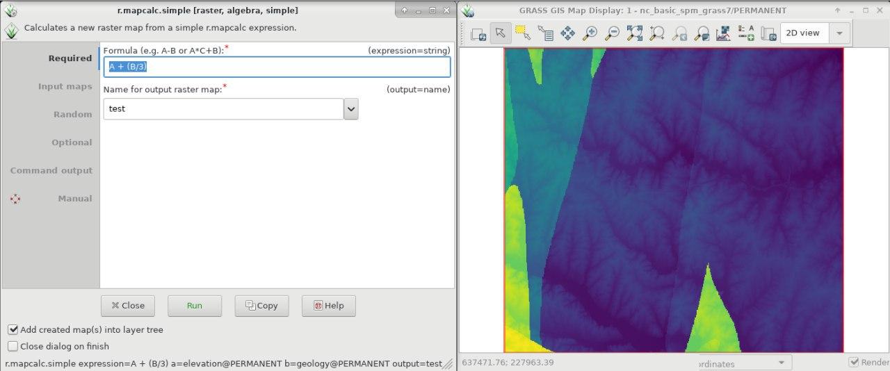
The new update release GRASS GIS 7.4.4 is release with a few bugfixes and the addition of r.mapcalc.simple esp. for QGIS integration. An overview of the new features in the 7.4 release series is available at New Features in GRASS GIS 7.4.

As a stable release series, 7.4.x enjoys long-term support.

Binaries/Installer download:

Source code download:

More details:

See also our detailed announcement:

About GRASS GIS

The Geographic Resources Analysis Support System (https://grass.osgeo.org/), commonly referred to as GRASS GIS, is an Open Source Geographic Information System providing powerful raster, vector and geospatial processing capabilities in a single integrated software suite. GRASS GIS includes tools for spatial modeling, visualization of raster and vector data, management and analysis of geospatial data, and the processing of satellite and aerial imagery. It also provides the capability to produce sophisticated presentation graphics and hardcopy maps. GRASS GIS has been translated into about twenty languages and supports a huge array of data formats. It can be used either as a stand-alone application or as backend for other software packages such as QGIS and R geostatistics. It is distributed freely under the terms of the GNU General Public License (GPL). GRASS GIS is a founding member of the Open Source Geospatial Foundation (OSGeo).

The GRASS Development Team, January 2019

qgis-icon_smallThanks to the work of Volker Fröhlich and other Fedora packagers I was able to create RPM packages of QGIS 2.18 Las Palmas for Fedora 23 and 24 using Fedora’s COPR platform.

Repo: https://copr.fedorainfracloud.org/coprs/neteler/QGIS-2.18-Las-Palmas

The following packages can now be installed:

  • qgis 2.18.0
  • qgis-debuginfo 2.18.0
  • qgis-devel 2.18.0
  • qgis-grass 2.18.0
  • qgis-python 2.18.0
  • qgis-server 2.18.0

Installation instructions (run as “root” user or use “sudo”):

su

# Fedora 23, Fedora 24:
dnf copr enable neteler/QGIS-2.18-Las-Palmas
dnf update
# note: the "qca-ossl" package is the OpenSSL plugin for QCA
dnf install qgis qgis-grass qgis-python qca-ossl

Enjoy!

Interestingly the WMS caching is not enabled by default in QGIS. To better enjoy WMS/WMS-C/WMTS connections – if you have some disk space to dedicate – it is a good idea to enable the cache in these few steps:

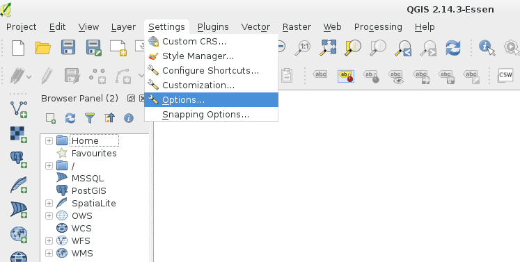
Go to the menu entry Settings >> Options:

Enabling the QGIS WMS cache - step 1

Enabling the QGIS WMS cache – step 1

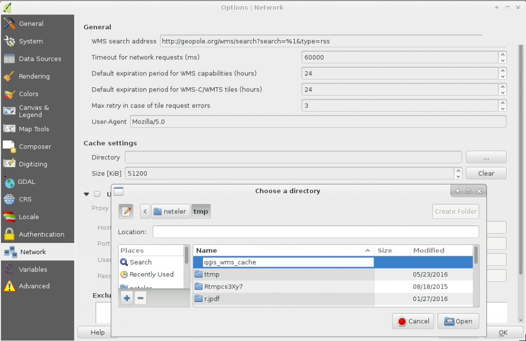
Go to tab “Network“. Therein, in “Cache settings“, select the “Directory” and choose a folder for the cache files. Be sure that there is free space for lots of megabytes can be stored there over time. And this directory should ideally be located on a fast disk (if you have several).

Here I choose the existing “tmp/” folder in my HOME directory and create inside a new folder “qgis_wms_cache”:

Enabling the QGIS WMS cache - step 2

Enabling the QGIS WMS cache – step 2: create new “qgis_wms_cache” cache folder

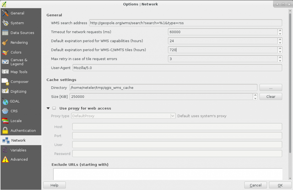
Eventually we change the “Default expiration period for WMS-C/WMTS tiles (hours)” to more than 24 hours (as it would be rather useless…). Here I change to 24*30 = 720 hours. And the cache size we increase as well, here to 250MB (written as 250000 since it is to be given in kilobytes):

Enabling the QGIS WMS cache - step 3

Enabling the QGIS WMS cache – step 3: increase expiration period for tiles and cache size

Now we press “OK” and close the dialog. Time to try out a WMS service, zoom back and forth… and:
Enjoy!

qgis-icon_smallThanks to the work of Volker Fröhlich and other Fedora/EPEL packagers I was able to create RPM packages of QGIS 2.10 Pisa for Fedora 21, Centos 7, and Scientific Linux 7 using the great COPR platform.

Repo: https://copr.fedoraproject.org/coprs/neteler/QGIS-2.10-Pisa/

The following packages can now be installed and tested on epel-7-x86_64 (Centos 7, Scientific Linux 7, etc.), and Fedora-21-x86_64:

  • qgis 2.10.1
  • qgis-debuginfo 2.10.1
  • qgis-devel 2.10.1
  • qgis-grass 2.10.1
  • qgis-python 2.10.1
  • qgis-server 2.10.1

Installation instructions (run as “root” user or use “sudo”):

su

# EPEL7:
yum install epel-release
yum update
wget -O /etc/yum.repos.d/qgis-2-10-epel-7.repo https://copr.fedorainfracloud.org/coprs/neteler/QGIS-2.10-Pisa/repo/epel-7/neteler-QGIS-2.10-Pisa-epel-7.repo
yum update
yum install qgis qgis-grass qgis-python

# Fedora 21:
dnf copr enable neteler/QGIS-2.10-Pisa
dnf update
dnf install qgis qgis-grass qgis-python

Enjoy!

qgis-icon_smallThanks to the work of Devrim Gündüz, Volker Fröhlich, Dave Johansen, Rex Dieter and other Fedora/EPEL packagers I had an easy going to prepare RPM packages of QGIS 2.8 Wien for Fedora 20 and 21, Centos 7, and Scientific Linux 7.

The base SRPM package I copied from Fedora’s koji server, modified the SPEC file in order to remove the now outdated PyQwt bindings (see bugzilla) and compiled QGIS 2.8 via the great COPR platform.

Repo: https://copr.fedoraproject.org/coprs/neteler/QGIS-2.8-Wien/

The following packages can now be installed and tested on epel-7-x86_64 (Centos 7, Scientific Linux 7, etc.), Fedora-20-x86_64, and Fedora-21-x86_64:

  • qgis 2.8.1
  • qgis-debuginfo 2.8.1
  • qgis-devel 2.8.1
  • qgis-grass 2.8.1
  • qgis-python 2.8.1
  • qgis-server 2.8.1

Installation instructions (run as “root” user or use “sudo”):

# EPEL7:
yum -y install epel-release
yum -y install wget
# https://copr.fedorainfracloud.org/coprs/neteler/python-OWSLib/
wget -O /etc/yum.repos.d/neteler-python-OWSLib-epel-7.repo https://copr.fedorainfracloud.org/coprs/neteler/python-OWSLib/repo/epel-7/neteler-python-OWSLib-epel-7.repo
yum -y update
yum -y install python-OWSLib
wget -O /etc/yum.repos.d/qgis-epel-7.repo https://copr.fedorainfracloud.org/coprs/neteler/QGIS-2.8-Wien/repo/epel-7/neteler-QGIS-2.8-Wien-epel-7.repo
yum update
yum install qgis qgis-grass qgis-python qgis-server

# Fedora 20:
wget -O /etc/yum.repos.d/qgis-epel-7.repo https://copr.fedorainfracloud.org/coprs/neteler/QGIS-2.8-Wien/repo/fedora-20/neteler-QGIS-2.8-Wien-fedora-20.repo
yum update
yum install qgis qgis-grass qgis-python qgis-server

# Fedora 21:
wget -O /etc/yum.repos.d/qgis-epel-7.repo https://copr.fedorainfracloud.org/coprs/neteler/QGIS-2.8-Wien/repo/fedora-21/neteler-QGIS-2.8-Wien-fedora-21.repo
yum update
yum install qgis qgis-grass qgis-python qgis-server

The other packages are optional (well, also qgis-grass, qgis-python, and qgis-server…).

Enjoy!

PS: Of course I hope that QGIS 2.8 officially hits EPEL7 anytime soon! My COPR repo is just a temporary bridge towards that goal.

EDIT 30 April 2015:

  • updated EPEL7 installation for python-OWSLib dependency

In the new release of QGIS 2.6.0 a series of new features have been added concerning

  • General: new features and bugfixes,
  • DXF export (improvements),
  • Map Composer (enhancements),
  • Processing (including a new modeler implementation),
  • QGIS Server (improvements),
  • Symbology (including user interface improvements),
  • User Interface with improvements.

A visual changelog is available for more details with lots of screenshots.

Congratulations to all QGIS developers! Looking forward to see the Fedora RPM available…

You can download QGIS 2.6 at https://qgis.org/en/site/forusers/download.html

We are pleased to announce that the 50th ICA-OSGeo Lab has been established at the GIS and Remote Sensing Unit (Piattaforma GIS & Remote Sensing, PGIS), Research and Innovation Centre (CRI), Fondazione Edmund Mach (FEM), Italy. CRI is a multifaceted research organization established in 2008 under the umbrella of FEM, a private research foundation funded by the government of Autonomous Province of Trento. CRI focuses on studies and innovations in the fields of agriculture, nutrition, and environment, with the aim to generate new sharing knowledge and to contribute to economic growth, social development and the overall improvement of quality of life.

The mission of the PGIS unit is to develop and provide multi-scale approaches for the description of 2-, 3- and 4-dimensional biological systems and processes. Core activities of the unit include acquisition, processing and validation of geo-physical, ecological and spatial datasets collected within various research projects and monitoring activities, along with advanced scientific analysis and data management. These studies involve multi-decadal change analysis of various ecological and physical parameters from continental to landscape level using satellite imagery and other climatic layers. The lab focuses on the geostatistical analysis of such information layers, the creation and processing of indicators, and the production of ecological, landscape genetics, eco-epidemiological and physiological models. The team pursues actively the development of innovative methods and their implementation in a GIS framework including the time series analysis of proximal and remote sensing data.

The GIS and Remote Sensing Unit (PGIS) members strongly support the peer reviewed approach of Free and Open Source software development which is perfectly in line with academic research. PGIS contributes extensively to the open source software development in geospatial (main contributors to GRASS GIS), often collaborating with various other developers and researchers around the globe. In the new ICA-OSGeo lab at FEM international PhD students, university students and trainees are present.

PGIS is focused on knowledge dissemination of open source tools through a series of courses designed for specific user requirement (schools, universities, research institutes), blogs, workshops and conferences. Their recent publication in Trends in Ecology and Evolution underlines the need on using Free and Open Source Software (FOSS) for completely open science. Dr. Markus Neteler, who is leading the group since its formation, has two decades of experience in developing and promoting open source GIS software. Being founding member of the Open Source Geospatial Foundation (OSGeo.org, USA), he served on its board of directors from 2006-2011. Luca Delucchi, focal point and responsible person for the new ICA-OSGeo Lab is member of the board of directors of the Associazione Italiana per l’Informazione Geografica Libera (GFOSS.it, the Italian Local Chapter of OSGeo). He contributes to several Free and Open Source software and open data projects as developer and trainer.

Details about the GIS and Remote Sensing Unit at https://gis.cri.fmach.it/

Open Source Geospatial Foundation (OSGeo) is a not-for-profit organisation founded in 2006 whose mission is to support and promote the collaborative development of open source geospatial technologies and data.

International Cartographic Association (ICA) is the world authoritative body for cartography and GIScience. See also the new ICA-OSGeo Labs website.

[toc]

Thanks to Volker Fröhlich’s efforts, a source code RPM package (SRPM) of QGIS 2.0.1 is now available for Fedora. If you are not yet F20 user (like me), you can just take the F20 package and compile it for F19 (or even F18) since there will be no backport of QGIS 2 to F19 (it comes with QGIS 1.8). But: we do want QGIS 2 on Fedora19!

Solution: compile it yourself.

1. Preparations

The best way is  to use “mock” which is used to recompile SRPMS in a separate local environment (“chroot”) without cluttering the system with extra packages needed for the compilation (run as “root”):

su
yum install mock

2. Get the source code

Next download the SRPM package from the Koji  server:
QGIS: https://koji.fedoraproject.org/koji/buildinfo?buildID=467757 (–> src – download) or check here for more recent versions.

3. Compile it locally as RPM package

The general compilation command (“mock”) would be:

mock -r my_fedora_version_config --rebuild my_source_rpm.src.rpm

So, check for Fedora version config name which is suitable for your system (“my_fedora_version_config“)

ls /etc/mock/

In my case of a 64bit machine, it is “fedora-19-x86_64”. Hence we can compile QGIS 2.0.1 directly from the SRPM file:

mock -r fedora-19-x86_64 --rebuild qgis-2.0.1-2.fc20.src.rpm

Note: the compilation takes 40min on my tiny core i3 laptop (ASUS X202). Use the time to donate some coins to the QGIS project :-)

4. Install and enjoy

Once the compilation job is done, i.e. the binary RPM files are available for installation. To install the freshly compiled QGIS 2.0.1 RPMs, run:

cd /var/lib/mock/fedora-19-x86_64/result/

# an existing QGIS1.8 installation will be replaced: 
yum localinstall qgis-2.0.1-2.fc19.x86_64.rpm \
qgis-grass-2.0.1-2.fc19.x86_64.rpm qgis-python-2.0.1-2.fc19.x86_64.rpm

# consider to cleanup (or keep it for the next update, it is about 1.5GB):
rm -rf /var/lib/mock/fedora-19-x86_64/
# leave the "root" shell
exit

Now we can happily use QGIS 2.0.1 on Fedora 19!

qgis

qgis201_on_fedora19

Have you been using GRASS GIS within your company or for your daily tasks? Would like to express your satisfaction and give something back to these terrific software developers to make them even happier during the July’s GRASS GIS Community Sprint in Prague?
Sure – so don’t think twice and support the developers with a (micro)donation!
Please contact Markus Neteler (neteler@osgeo.org – GRASS GIS PSC Chair) for further details.
Wait – it is also possible to buy a round of beer for the developers with a quick click using the PayPal “Buy [pizza/beer/…] Now” button below: (… more pizza & beer for the developers)

About the Community Sprint

A “Community Sprint” is a get-together for members and supporters of GRASS GIS and related OSGeo projects to make decisions and tackle larger problems. Developers and contributors are donating their valuable time, so appreciate direct or in-kind funding made available for the sprint meeting to cover out-of-pocket expenses. All of the work that takes place at the community sprint will be directly contributed back into the GRASS GIS project to the benefit of everyone who uses it.
See the outstanding results from 2011, and 2012!

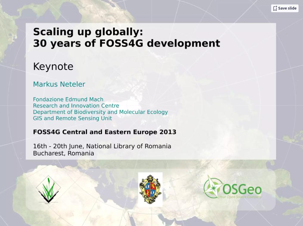
In my presentation I briefly review 3 decades of Open Source GIS development, from the 1980th to the present.

See my slides:

Scaling up globally: 30 years of FOSS4G development. Keynote at FOSS4G-CEE 2013, Romania by Markus Neteler


Presentation file: Download presentation file (ODP) to get all the clickable links working!