Drowning in too many maps? Have some fun exploring fascinating geometries of changing landscapes in Space Time Cube and creating 2D and 3D animations from time series of geospatial data. Learn about the new capabilities for spatio-temporal data handling in GRASS GIS 7 (https://grass.osgeo.org/grass7/) and explore various techniques for dynamic visualizations.
First, we will introduce you to GRASS GIS 7, including its spatio-temporal capabilities and you will learn how to manage and analyze geospatial data time series. Then, we will explore new tools for visualization of spatio-temporal data. You will create both 2D and 3D dynamic visualizations directly in GRASS GIS 7. Additionally, we will explain the Space Time Cube concept using various applications based on raster and vector data time series. You will learn to manage and visualize data in space time cubes (voxel models). No prior knowledge of GRASS GIS is necessary, we will cover the basics needed for the workshop. All relevant material including an overview of the tools and hands-on practical instructions along with the sample data sets will be available on-line. And, by the way, GRASS GIS is a free and open source geographic information system (GIS) used for geospatial data management, analysis, modeling, image processing, and visualization which runs on Linux, MS Windows, Mac OS X and other systems.
Presenters: Vaclav Petras, Anna Petrasova, Helena Mitasova, Markus Neteler
When: FOSS4G 2014, Sept 8th-13th 2014, Portland, OR, USA
https://neteler.org/wp-content/uploads/2024/01/wg_neteler_logo.png00Markushttps://neteler.org/wp-content/uploads/2024/01/wg_neteler_logo.pngMarkus2014-04-12 14:30:422023-10-22 18:52:00Workshop at FOSS4G 2014: Spatio-temporal data handling and visualization in GRASS GIS 7
LiDAR point cloud data are commonly delivered in the ASPRS LAS format. The format is supported by libLAS, a BSD-licensed C++ library for reading/writing these data. GRASS GIS 7 supports the LAS format directly when built against libLAS (as the case for most binary packages being available for download).
In this exercise we will import a sample LAS data set covering a tiny area close to Raleigh, NC (USA), belonging to the North Carolina sample data set. Sample LAS data download: https://grass.osgeo.org/sampledata/north_carolina/ (25MB).
For a full exercise, we will, however, assume that no GRASS GIS location is ready so far (so: newbies are welcome!) and create a new one initially.
1. Having the LAS file: now what?
In the first place, check the metadata of the LAS file using the lasinfo command (comes with libLAS; here only parts of the output shown):
lasinfo points.las
---------------------------------------------------------
  Header Summary
---------------------------------------------------------
  Version:  1.2
  Source ID:  0
  Reserved:  0
  Project ID/GUID:  '00000000-0000-0000-0000-000000000000'
  System ID:  'libLAS'
  Generating Software:  'libLAS 1.2'
[...]
  Spatial Reference:
None
[...]
---------------------------------------------------------
  Point Inspection Summary
---------------------------------------------------------
  Header Point Count: 1287775
  Actual Point Count: 1287775

  Minimum and Maximum Attributes (min,max)
---------------------------------------------------------
  Min X, Y, Z:   6066629.86, 2190053.45, -3.60
  Max X, Y, Z:   6070237.92, 2193507.74, 906.00
  Bounding Box:  6066629.86, 2190053.45, 6070237.92, 2193507.74
  Time:  0.000000, 0.000000
  Return Number:  1, 3
  Return Count:  1, 7
  Flightline Edge:  0, 0
  Intensity:  0, 256
  Scan Direction Flag:  0, 0
  Scan Angle Rank:  0, 0
  Classification:  2, 7
  Point Source Id:  0, 0
  User Data:  0, 0
  Minimum Color (RGB):  0 0 0
  Maximum Color (RGB):  0 0 0

  Number of Points by Return
---------------------------------------------------------
  (1) 1225886  (2) 61430  (3) 459

  Number of Returns by Pulse
---------------------------------------------------------
  (1) 30877  (2) 153  (5) 1225886  (6) 30706  (7) 153

  Point Classifications
---------------------------------------------------------
  647337 Ground (2)
  639673 Low Vegetation (3)
  740 Building (6)
  25 Low Point (noise) (7)
  -------------------------------------------------------
  0 withheld
  0 keypoint
  0 synthetic
  -------------------------------------------------------
We see: no spatial reference system indicated!
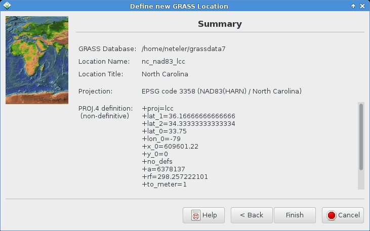
Luckily we know from here that the projection is NAD83(HARN) / North Carolina, LCC 2SP metric, EPSG code 3358). Furthermore we see:
Number of Points by Return: 3 (i.e., first, mid, last)
Point Classifications: the points are already classified as “Ground” (class 2), “Low Vegetation” (3), “Building” (6), and Low Point (noise) (class 7). Something to play with later.
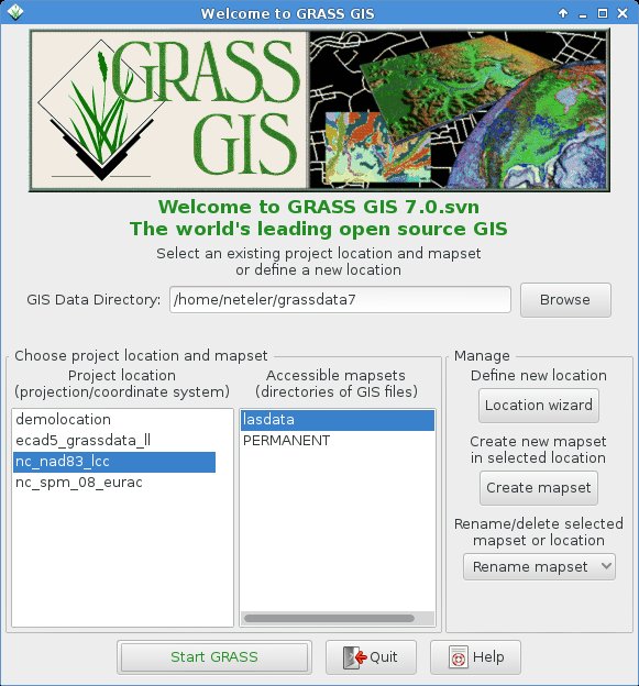
Time to create a GRASS GIS location and import the LAS file.
2. Creating a GRASS GIS location for the LAS file
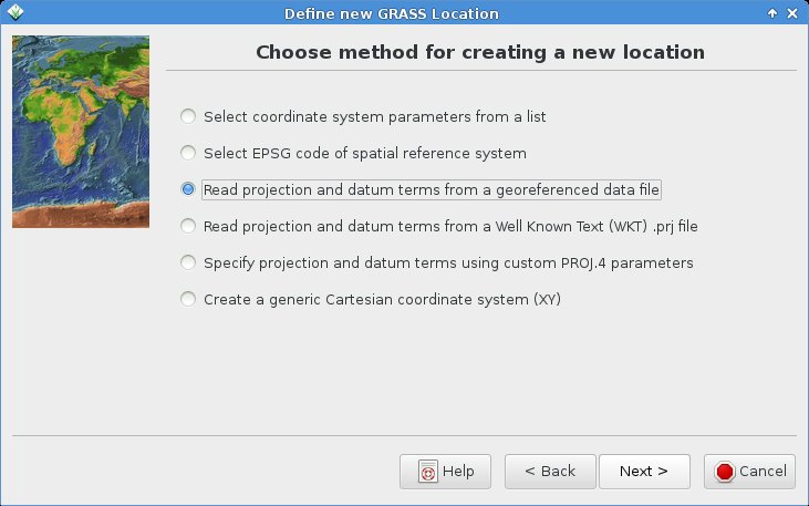
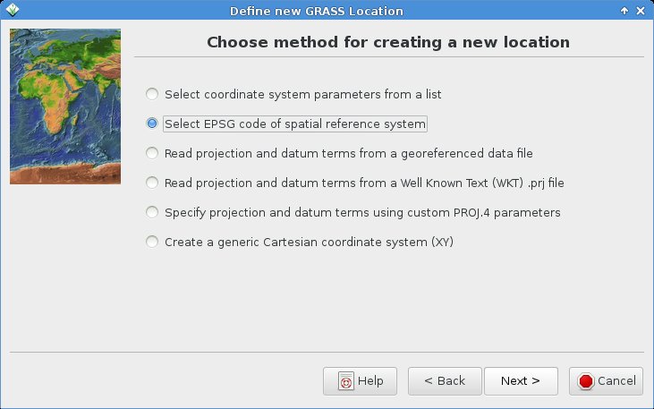
Since we know the EPSG code of the projection, that’s an easy task. Please note that GRASS GIS can generate locations directly from SHAPE files (with .prj file), GeoTIFF and more.
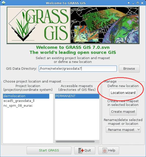
We fire up GRASS GIS 7 and open the Location Wizard:
In the Location Wizard, we first define a name for the new location:
We select the “EPSG code” method for creating a new location:
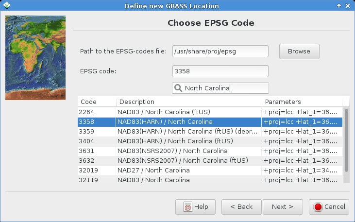
You can search for “North Carolina” and select the EPSG code 3358 from the list:
Next summary should show up as follows (be sure to have the metric projection shown!):
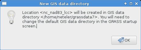
With “Finish” you reach this notification (indeed, nothing to change! It is already fine):
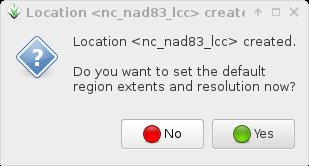
Since we want to import the LAS file, no need to manually define any region extent here – just say “No”:
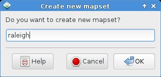
While we could import the data also into the PERMANENT mapset, we prefer to create an own mapset “lasdata” for our LAS data (once you reach hundreds of maps to manage, you will be happy about the concept of mapsets):
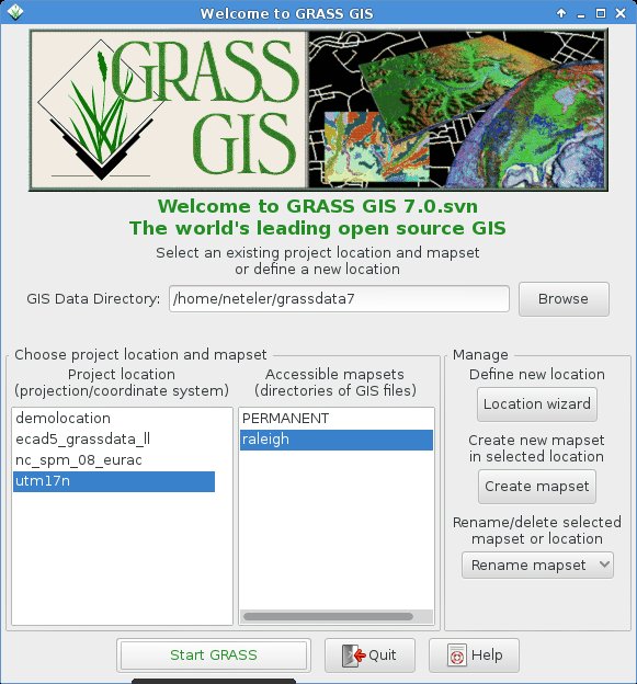
Voilà , we get back to the initial startup screen and can now start our GRASS GIS session with our “nc_nad83_lcc” location and “lasdata” mapset within the location: “Start GRASS”!
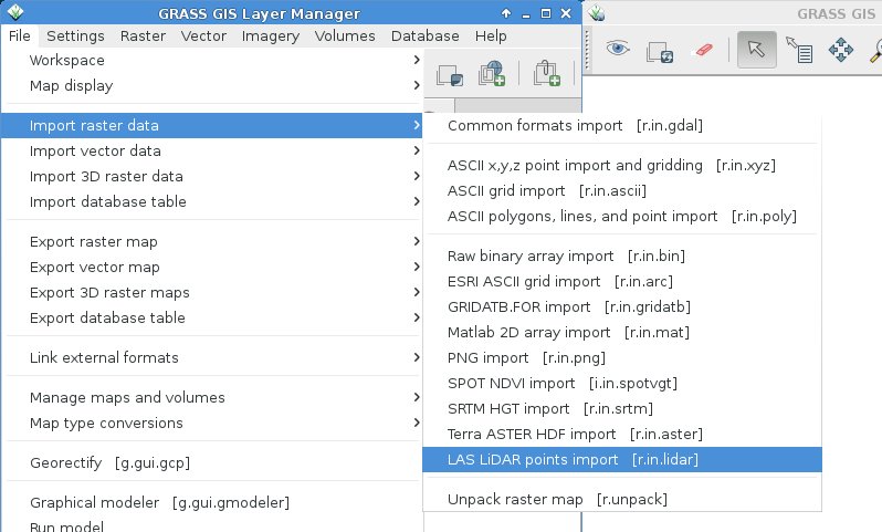
3. Import of the LAS file
When creating a new location from a GeoTIFF or SHAPE file (or other GDAL supported format), then the data set is imported right away. This is not the case for LAS files, also due to the fact that we can directly apply binning statistics during import of the LAS file (e.g. percentiles, min or max) and create a raster surface from the points right away rather than importing them as vector points.
3. a) Creating a raster surface from LAS during import
The LAS import into a raster surface is available through r.in.lidar:
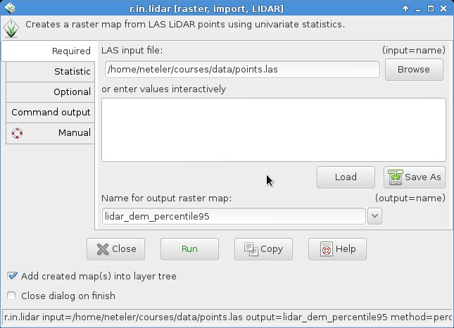
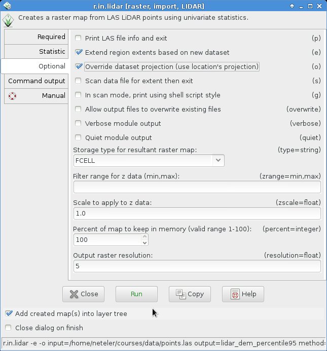
First the LAS file needs to be selected and an output file name specified (in this example, we want to extract the 95th percentile as binning method, hence a reasonable map name):
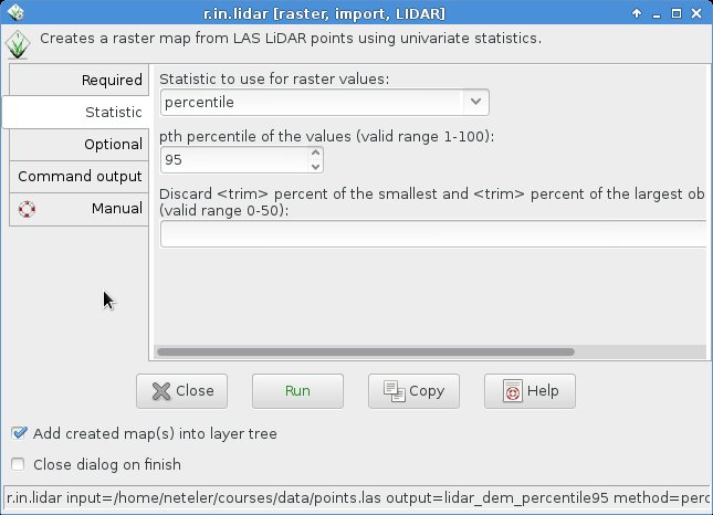
In the “Statistic” tab, we select the “percentile” method along with 95 as value:
In the “Optional” tab we activate to extend the computational region from the LAS file and, since the spatial reference system metadata are lacking from the LAS file, also “override dataset projection” to use that predefined in the location. Finally, we define 5m as desired raster resolution for the resulting raster map:
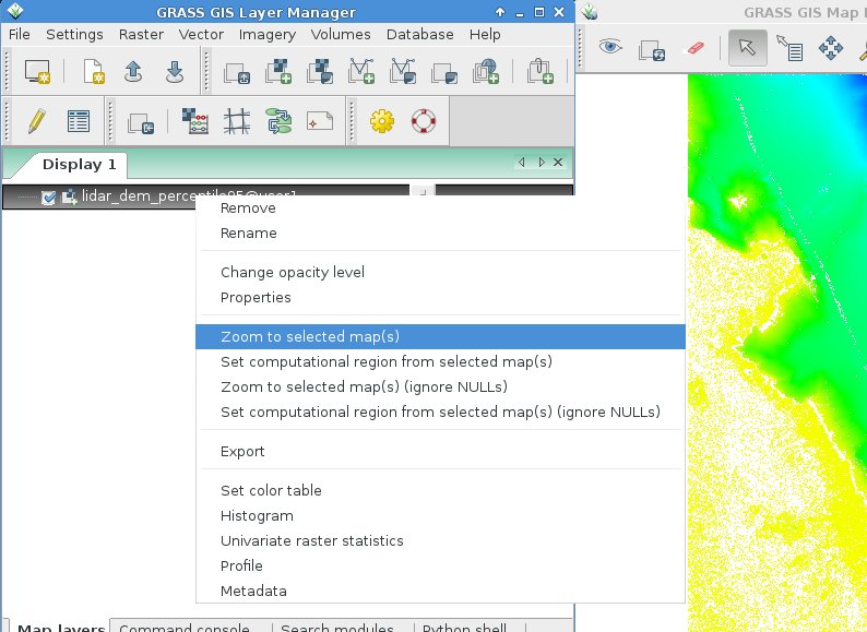
Upon conpletion of the import/binning, the new raster elevation map is shown after zooming to the map (r.in.lidar -e … restores upon completion the previous region settings, hence we may have to zoom):
Now we can start to analyze or visually explore the imported LAS file.
4. Visual LiDAR data exploration
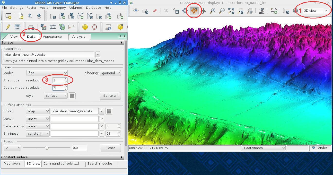
Using the wxNVIZ 3D viewer, we can easily fly through the new DEM. Switch in the Map Display to “3D view” (1). Note that the default rendering is initially done at low visual resolution for speed reasons. You can switch to “Rotate mode” as well to easily navigate with the mouse. In the “Data” tab (2) you can increase the visual resolution (3) to obtain a crisp view:
https://neteler.org/wp-content/uploads/2024/01/wg_neteler_logo.png00Markushttps://neteler.org/wp-content/uploads/2024/01/wg_neteler_logo.pngMarkus2014-02-23 22:45:082023-11-20 16:35:14Importing and visualizing LAS LiDAR files in GRASS GIS 7: r.in.lidar
Recently, in order to nicely plan ahead for a birthday lunch at the agriturismo Malga Brigolina (a farm-restaurant near Sopramonte di Trento, Italy, at 1,000m a.s.l. in the Southern Alps), friends of mine asked me the day before:
“Will the place be sunny at lunch time for making a nice walk?“
[well, the weather was close to clear sky conditions but mountains are high here and cast long shadows in winter time].
A rather easy task I thought, so I got my tools ready since that was an occasion to verify the predictions with some photos! Thanks to the new EU-DEM at 25m I was able to perform the computations right away in a metric system rather than dealing with degree in LatLong.
Direct sunlight can be assessed from the beam radiation map of GRASS GIS’ r.sun when running it for a specific day and time. But even easier, there is a new Addon for GRASS GIS 7 which calculates right away time series of insolation maps given start/stop timestamps and a time step: r.sun.hourly. This shrinks the overall effort to almost nothing.
Creating the direct sunlight maps
The first step is to calculate where direct sunlight reaches the ground. Here the input elevation map is the European “eu_dem_25”, while the output is the beam radiation for a certain day (15 Dec 2013 is DOY 349).
Important hint: the computational region must be large enough to east/south/west to capure the cast shadow effects of all relevant surrounding mountains.
I let calculations start at 8am and finish at 5pm which an hourly time step. The authors have kindly parallelized r.sun.hourly, so I let it run on four processors simultaneously to speed up:
# calculate DOY (day-of-year) from given date:
date -d 2013-12-15 +%j
349

# calculate beam radiation maps for a given time period
# (note: minutes are to be given in decimal time: 30min = 0.5)
r.sun.hourly elev_in=eu_dem_25 beam_rad=trento_beam_doy349 \
      start_time=8 end_time=17 time_step=1 day=349 year=2013 \
      nprocs=4
The ten resulting maps contain the beam radiation for each pixel considering the cast shadow effects of the pixel-surrounding mountains. However, the question was not to calculate irradiance raster maps in Wh/m^2 but simply “sun-yes” or “sun-no”. So a subsequent filtering had to be applied. Each beam radiation map was filtered: if pixel value equal to 0 then “sun-no”, otherwise “sun-yes” (what my friends wanted to achieve; effectively a conversion into a binary map).
Best done in a simple shell script loop:
for map in `g.mlist rast pattern="trento_beam_doy349*"` ; do
    # rename current map to tmp
    g.rename rast=$map,$map.tmp
    # filter and save with original name
    r.mapcalc "$map = if($map.tmp == 0, null(), 1)"
    # colorize the binary map
    echo "1 yellow" | r.colors $map rules=-
    # remove cruft
    g.remove rast=$map.tmp
done
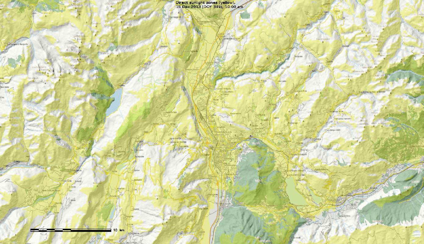
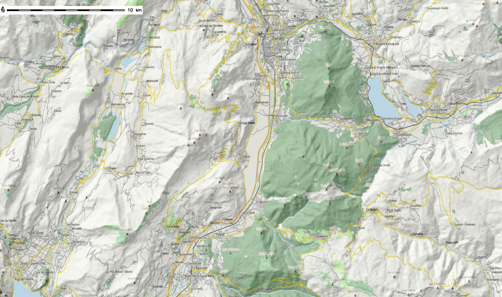
As a result we got ten binary maps, ideal for using them as overlay with shaded DEMs or OpenStreetMap layers. The areas exposed to direct sunlight are shown in yellow.
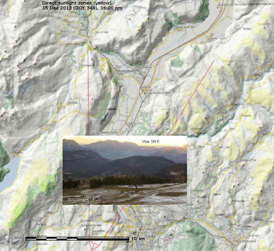
Trento, direct sunlight, 15 Dec 2013 between 10am and 5pm (See here for creating an animated GIF). Quality reduced for this blog.
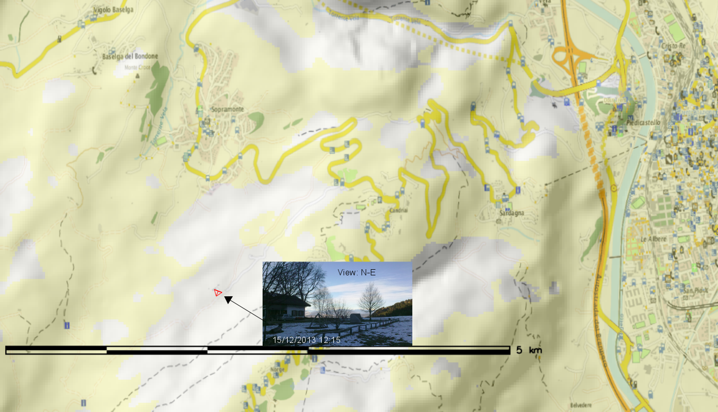
Time to look at some details: So, is Malga Brigolina in sunlight at lunch time?
Situation at 12pm (noon): predicted that the restaurant is still in shadow – confirmed in the photo:
(click to enlarge)
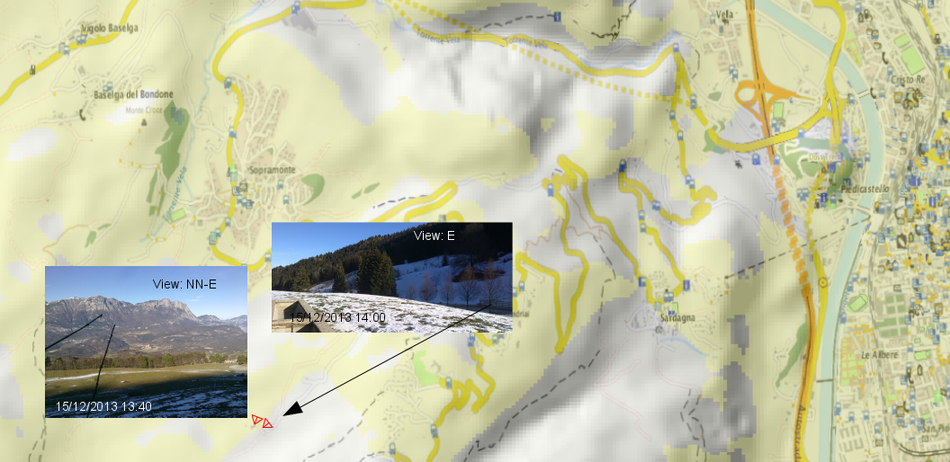
Situation at 1:30/2:00pm: sun is getting closer to the Malga, as confirmed in photo (note that the left photo is 20min ahead of the map). The small street in the right photo is still in the shadow as predicted in the map):
(click to enlarge)
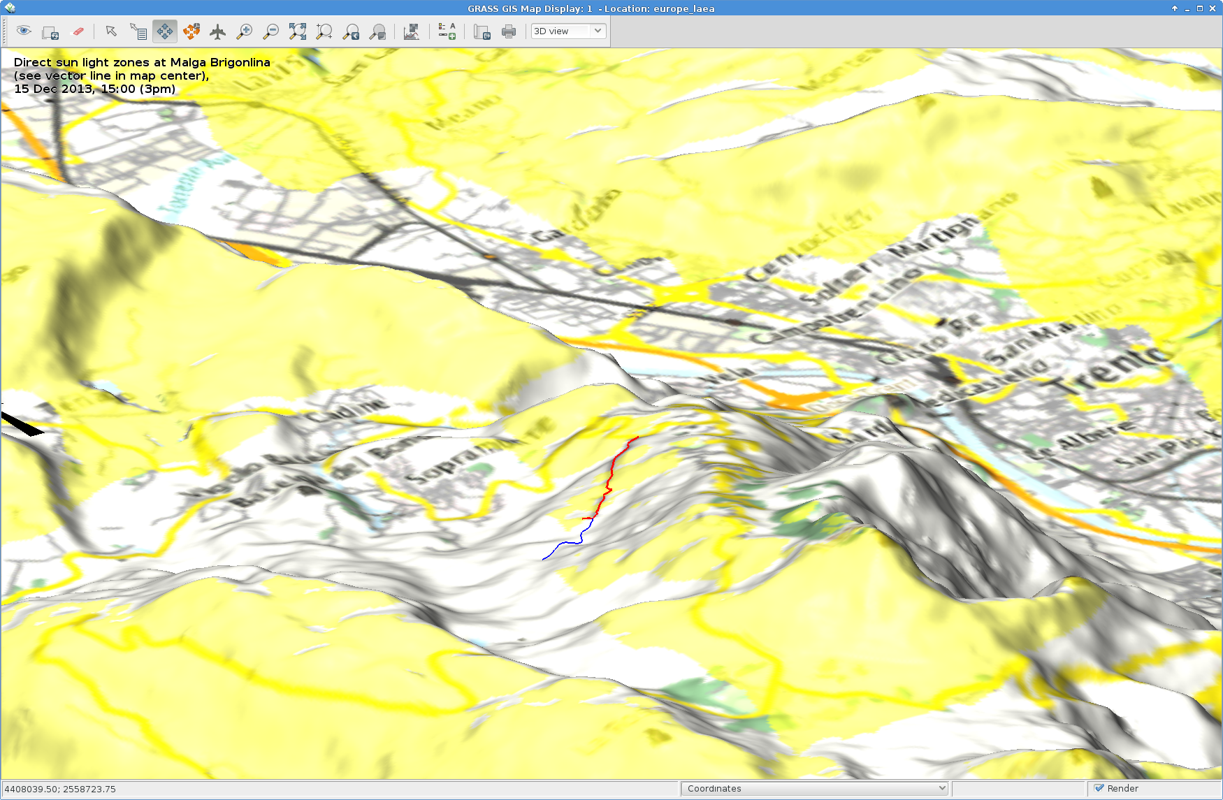
Situation at 3:00pm: sun here and there at Malga Brigolina:
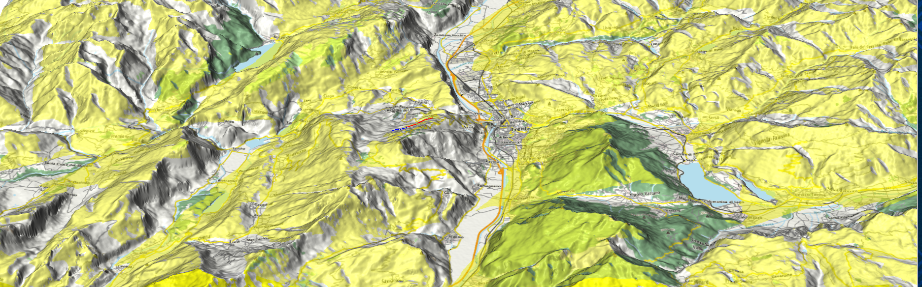
Sunlight map blended with OpenStreetmap layer (r.blend + r.composite) and draped over DEM in wxNVIZ of GRASS GIS 7 (click to enlarge). The sunday walk path around Malga Brigolina is the blue/red vector line shown in the view center.
Situation at 4:00pm: we are close to sunset in Trentino… view towards the Rotaliana (Mezzocorona, S. Michele all’Adige), last sunlit summits also seen in photo:
(click to enlarge)
Outcome
The resulting sunlight/shadow map appear to match nicely realty. Perhaps r.sun.hourly should get an additional flag to generate the binary “sun-yes” – “sun-no” maps directly.
Direct sunlight zones (yellow, 15 Dec 2013, 3pm): Trento with Monte Bondone, Paganella, Marzolan, Lago di Caldonazzo, Lago di Levico and surroundings (click to enlarge)
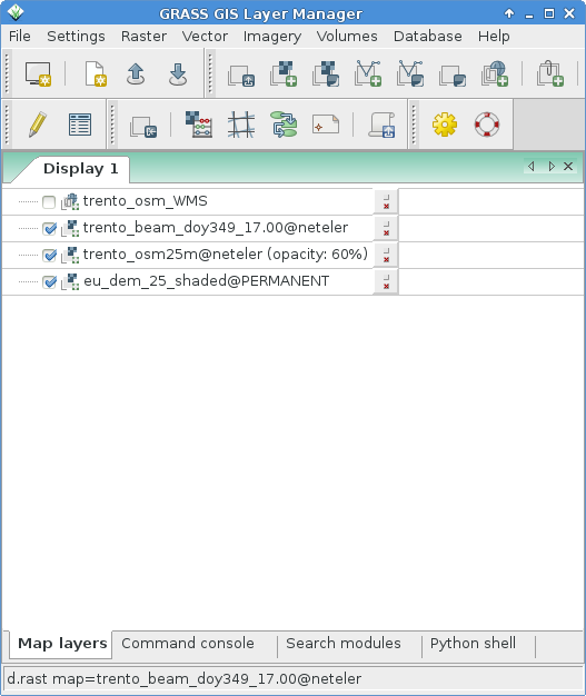
GRASS GIS usage note
The wxGUI settings were as simple as this (note the transparency values for the various layers):
https://neteler.org/wp-content/uploads/2024/01/wg_neteler_logo.png00Markushttps://neteler.org/wp-content/uploads/2024/01/wg_neteler_logo.pngMarkus2013-12-27 21:52:402023-11-20 10:13:45Will the sun shine on us?
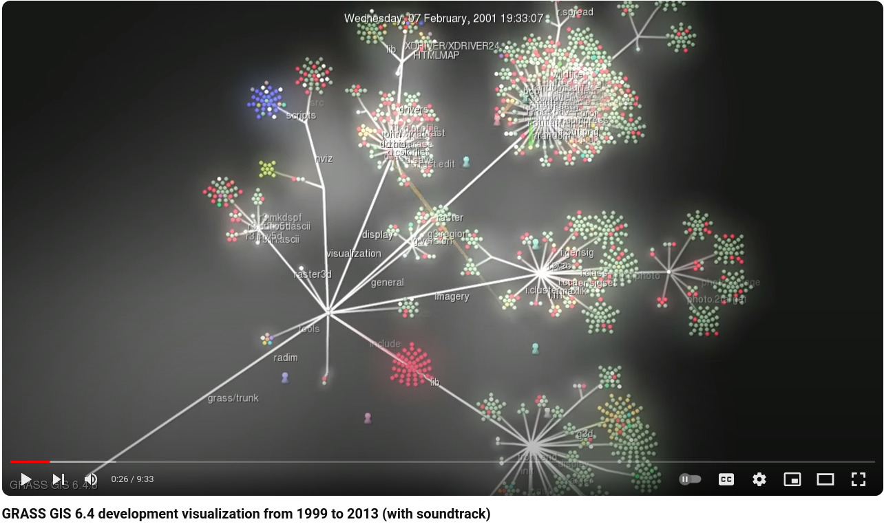
Watch how the community based GRASS GIS 6.4 software development evolved! You can see how the individual contributors modify and expand the source code – click screenshot for Youtube video:
Dec 29, 1999: GRASS GIS 5.0 is being stored in an online source code repository in December 1999…
Dec 02, 2000: The developers work on all parts of the code…
Jan 15, 2002: Working on the future GRASS GIS 5.1 release
Nov 25, 2002: Starting GRASS 5.1 development with code restructuring
Jun 14, 2004: GRASS GIS 5.7 released in June 2004
Nov 09, 2004: Source code restructuring to get a better directory layout (all other developers waiting…)
Nov 09, 2004: … thousands of files are modified in this operation …
Nov 10, 2004: All developers resume their activities after the restructuring
Jan 10, 2005: Preparing the GRASS GIS 6.0.0 release…
Apr 09, 2005: GRASS GIS 6.0.0 published, release branch being split off from trunk for easier maintenance
Feb 22, 2006: Release of GRASS GIS 6.0.2 and new source code refactoring startedApr 05, 2006: Heavy development activity in trunk (development branch) …
Oct 25, 2006: GRASS GIS 6.2.0 released in October 2006
Apr 10, 2007: Preparing the GRASS GIS 6.2.2 release…
Jun 16, 2007: GRASS GIS 6.2.2 released in June 2007
Nov 01, 2007: Raster and vector modules being actively maintained…
Apr 02, 2007: New graphical user interface development speeding up (wxGUI)
Feb 20, 2008: Copyright statements prettified in many files
May 31, 2008: New GRASS 6 development branch being split off from trunk (which becomes GRASS 7)
Jun 10, 2008: Developers moving over to new branch
Feb 23, 2009: GRASS 6.4 release branch split off from GRASS 6 development branch
https://neteler.org/wp-content/uploads/2024/01/wg_neteler_logo.png00Markushttps://neteler.org/wp-content/uploads/2024/01/wg_neteler_logo.pngMarkus2013-12-18 08:01:182024-01-22 20:39:27Video: GRASS GIS development visualization from 1999 to 2013
To warm up, I registered the “normally” shaded DEM (previously generated with gdaldem) with r.external in a GRASS GIS 7 location (EPSG 3035, LAEA) and overlayed the OpenStreetMap layer using WMS with GRASS 7’s r.in.wms. An easy task thanks to University of Heidelberg’s www.osm-wms.de. Indeed, they offer a similar shading via WMS, however, in the screenshot below you see the new EU data being used for controlling the light on our own:
OpenStreetMap shaded with EU DEM 25m (click to enlarge)
Next item: trying r.shaded.pca… It supports multi-core calculation and the possibility to strengthen the effects through z-rescaling. In my example, I used:
https://neteler.org/wp-content/uploads/2024/01/wg_neteler_logo.png00Markushttps://neteler.org/wp-content/uploads/2024/01/wg_neteler_logo.pngMarkus2013-12-15 00:34:052023-11-20 10:13:45Using the 25m EU-DEM for shading OpenStreetMap layers
GRASS GIS, commonly referred to as GRASS (Geographic Resources Analysis Support System), is the free Geographic Information System (GIS) software with the longest record of development as FOSS4G community project. The increasing demand for a robust and modern analytical free GIS led to the start of GRASS GIS 7 development in April 2008. Since GRASS 6 more than 10,000 changes have been implemented with a series of new modules for vector network analysis, image processing, voxel analysis, time series management and improved graphical user interface. The core system offers a new Python API and large file support for massive data analysis. Many modules have been undergone major optimization also in terms of speed. The presentation will highlight the advantages for users to migrate to the upcoming GRASS GIS 7 release.
We are pleased to announce that the 50th ICA-OSGeo Lab has been established at the GIS and Remote Sensing Unit (Piattaforma GIS & Remote Sensing, PGIS), Research and Innovation Centre (CRI), Fondazione Edmund Mach (FEM), Italy. CRI is a multifaceted research organization established in 2008 under the umbrella of FEM, a private research foundation funded by the government of Autonomous Province of Trento. CRI focuses on studies and innovations in the fields of agriculture, nutrition, and environment, with the aim to generate new sharing knowledge and to contribute to economic growth, social development and the overall improvement of quality of life.
The mission of the PGIS unit is to develop and provide multi-scale approaches for the description of 2-, 3- and 4-dimensional biological systems and processes. Core activities of the unit include acquisition, processing and validation of geo-physical, ecological and spatial datasets collected within various research projects and monitoring activities, along with advanced scientific analysis and data management. These studies involve multi-decadal change analysis of various ecological and physical parameters from continental to landscape level using satellite imagery and other climatic layers. The lab focuses on the geostatistical analysis of such information layers, the creation and processing of indicators, and the production of ecological, landscape genetics, eco-epidemiological and physiological models. The team pursues actively the development of innovative methods and their implementation in a GIS framework including the time series analysis of proximal and remote sensing data.
The GIS and Remote Sensing Unit (PGIS) members strongly support the peer reviewed approach of Free and Open Source software development which is perfectly in line with academic research. PGIS contributes extensively to the open source software development in geospatial (main contributors to GRASS GIS), often collaborating with various other developers and researchers around the globe. In the new ICA-OSGeo lab at FEM international PhD students, university students and trainees are present.
PGIS is focused on knowledge dissemination of open source tools through a series of courses designed for specific user requirement (schools, universities, research institutes), blogs, workshops and conferences. Their recent publication in Trends in Ecology and Evolution underlines the need on using Free and Open Source Software (FOSS) for completely open science. Dr. Markus Neteler, who is leading the group since its formation, has two decades of experience in developing and promoting open source GIS software. Being founding member of the Open Source Geospatial Foundation (OSGeo.org, USA), he served on its board of directors from 2006-2011. Luca Delucchi, focal point and responsible person for the new ICA-OSGeo Lab is member of the board of directors of the Associazione Italiana per l’Informazione Geografica Libera (GFOSS.it, the Italian Local Chapter of OSGeo). He contributes to several Free and Open Source software and open data projects as developer and trainer.
Open Source Geospatial Foundation (OSGeo) is a not-for-profit organisation founded in 2006 whose mission is to support and promote the collaborative development of open source geospatial technologies and data.
International Cartographic Association (ICA) is the world authoritative body for cartography and GIScience. See also the new ICA-OSGeo Labs website.
https://neteler.org/wp-content/uploads/2024/01/wg_neteler_logo.png00Markushttps://neteler.org/wp-content/uploads/2024/01/wg_neteler_logo.pngMarkus2013-10-23 16:06:302023-11-20 10:17:3950th ICA-OSGeo Lab established at Fondazione Edmund Mach (FEM)
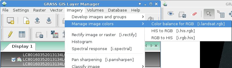
Here we will try color balancing and pan-sharpening, i.e. applying the higher resolution panchromatic channel to the color channels, using i.colors.enhance (former i.landsat.rgb).
Landsat 8 – RGB color balancing: natural color composites
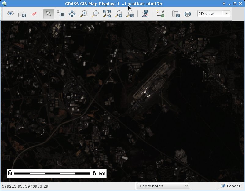
After import, the RGB (bands 4,3,2 for Landsat 8) may look initially less exciting than expected.This is easy to fix by a histogram based auto-balancing of the RGB color tables.
To brighten up the RGB composite, we can use the color balancing tool of GRASS GIS 7:
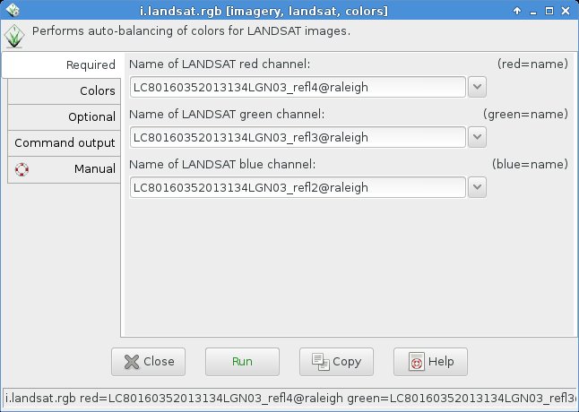
As input, we specify the bands 4, 3, and 2:
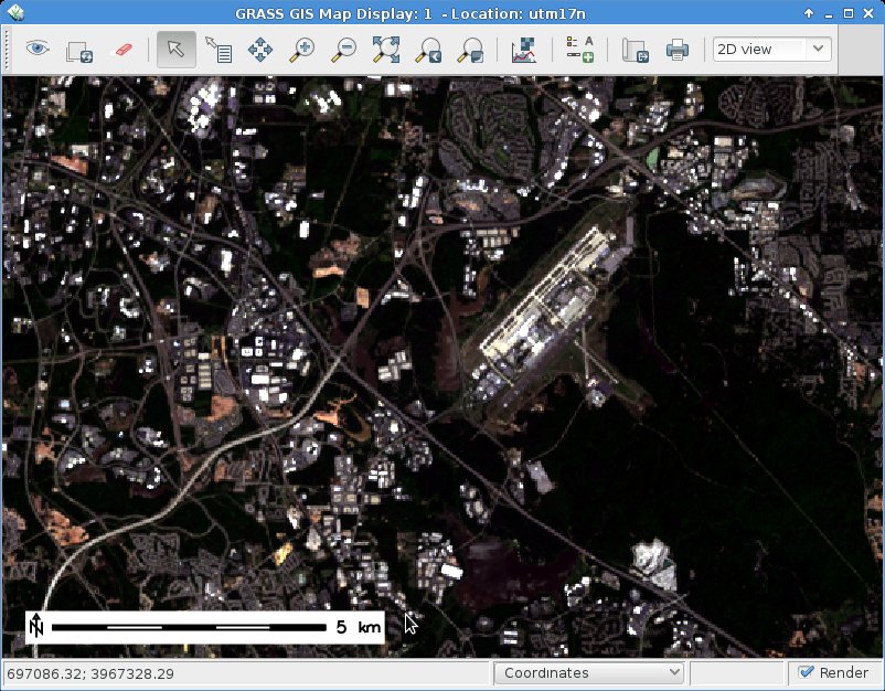
Using a “Cropping intensity (upper brightness level)” of 99 (percent), the result look as follows:
For special purposes or under certain atmospheric/ground conditions it may be useful to make use of the functions “Preserve relative colors, adjust brightness only” or “Extend colors to full range of data on each channel” in the “Optional” tab of i.colors.enhance (former i.landsat.rgb).
You will need to experiment since the results depend directly on the image data.
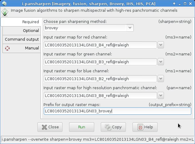
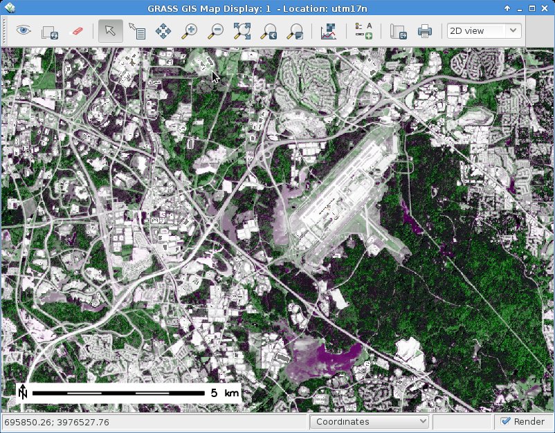
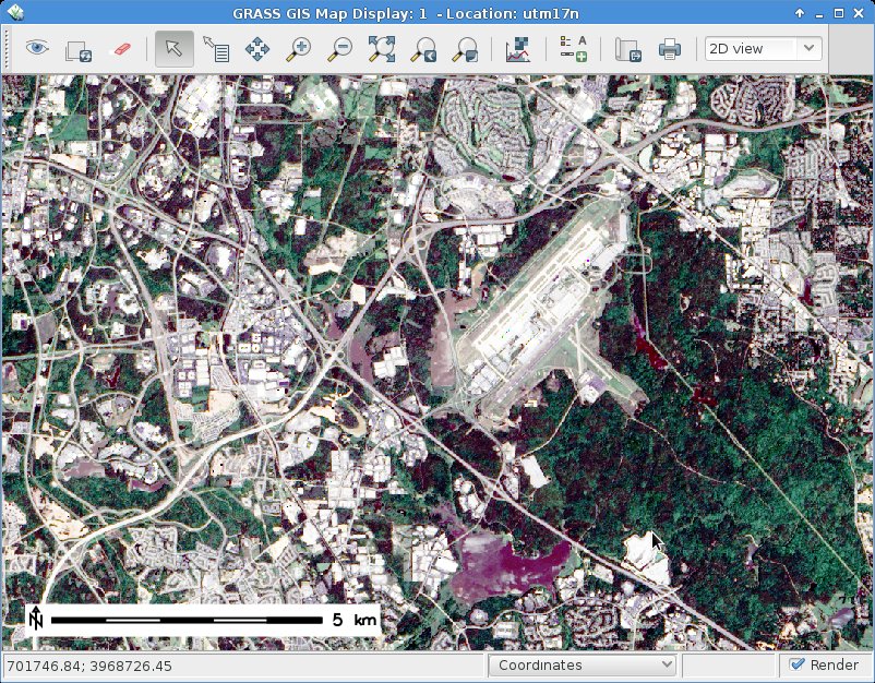
Landsat 8 pansharpening
Pansharpening is a technique to merge the higher geometrical pixel resolution of the panchromatic band (Band 8) with the lower resolution color bands (Bands 4, 3, 2).
This module runs in multi-core mode parallelized. The management of the resolution (i.e., apply the higher resolution of the panchromatic band) is performed automatically.
2. IHS transform
Here we select as above the bands in the i.pansharpen interface but use the “ihs” method.
HINT: If the colors should look odd, then apply i.colors.enhance (former i.landsat.rgb) to the pan-sharpened bands (see above).
https://neteler.org/wp-content/uploads/2024/01/wg_neteler_logo.png00Markushttps://neteler.org/wp-content/uploads/2024/01/wg_neteler_logo.pngMarkus2013-10-05 00:32:002023-11-20 16:46:20Processing Landsat 8 data in GRASS GIS 7: RGB composites and pan sharpening
The Landsat 8 mission is a collaboration between the U.S. Geological Survey (USGS) and National Aeronautics and Space Administration (NASA) which continues the acquisition of high-quality data for observing land use and land cover change.
The Landsat 8 spacecraft which was launched in 2013 carries they following key instruments:
OLI: the Operational Land Imager which collects data in the visible, near infrared, and shortwave infrared wavelength regions as well as a panchromatic band. With respect to Landsat 7 two new spectral bands have been added: a deep-blue band for coastal water and aerosol studies (band 1), and a band for cirrus cloud detection (band 9). Furthermore, a Quality Assurance band (BQA) is also included to indicate the presence of terrain shadowing, data artifacts, and clouds.
TIRS: The Thermal Infrared Sensor continues thermal imaging and is also intended to support emerging applications such as modeling evapotranspiration for monitoring water use consumption over irrigated lands.
The data from Landsat 8 are available for download at no charge and with no user restrictions.
Using the “Download options”, you can download the data set (requires login). Select the choice:
[x] Level 1 GeoTIFF Data Product (842.4 MB)
You will receive the file “LC80160352013134LGN03.tar.gz”.
Unpacking the downloaded Landsat 8 dataset
To unpack the data, run (or use a graphical tool at your choice):
tar xvfz LC80160352013134LGN03.tar.gz
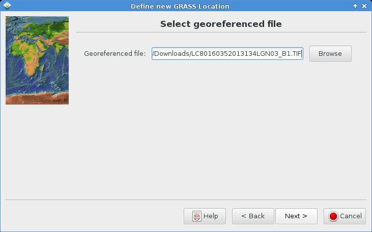
A series of GeoTIFF files will be extracted: LC80160352013134LGN03_B1.TIF, LC80160352013134LGN03_B2.TIF, LC80160352013134LGN03_B3.TIF, LC80160352013134LGN03_B4.TIF, LC80160352013134LGN03_B5.TIF, LC80160352013134LGN03_B6.TIF, LC80160352013134LGN03_B7.TIF, LC80160352013134LGN03_B8.TIF, LC80160352013134LGN03_B9.TIF, LC80160352013134LGN03_B10.TIF, LC80160352013134LGN03_B11.TIF, LC80160352013134LGN03_BQA.TIF
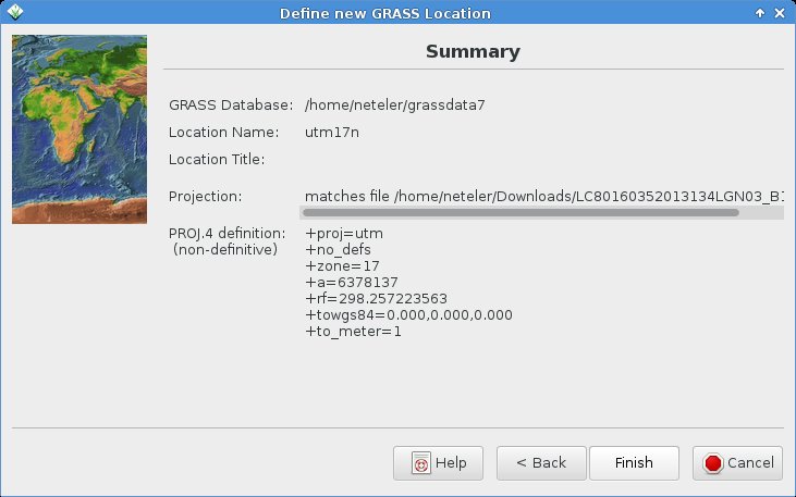
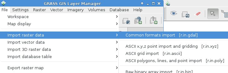
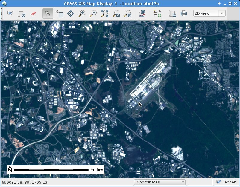
Note: While this Landsat 8 scene covers the area of the North Carolina (NC) sample dataset, it is delivered in UTM rather than the NC’s state plane metric projection. Hence we preprocess the data first in its original UTM projection prior to the reprojection to NC SPM.
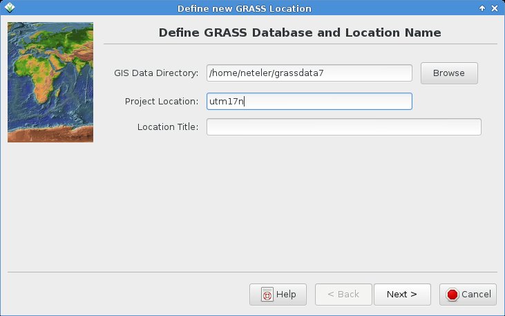
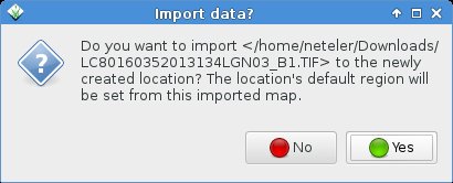
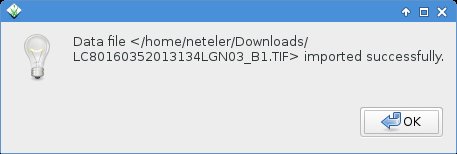
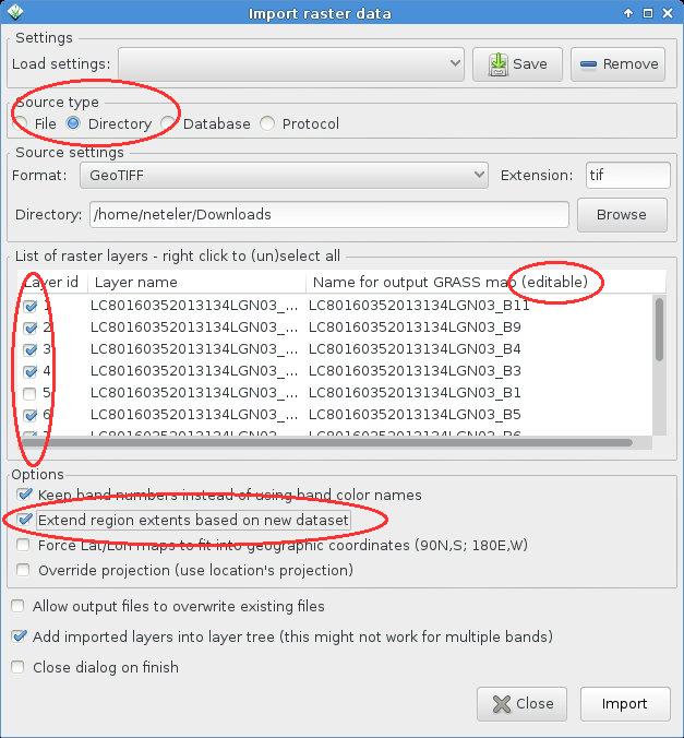
Using the Location Wizard, we can import the dataset easily into a new location (in case you don’t have UTM17N not already created earlier):
grass70 -gui
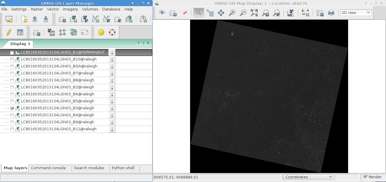
Now start GRASS GIS 7 and you will find the first band already imported (the others will follow shortly!).
For the lazy folks among us, we can also create a new GRASS GIS Location right away from the dataset on command line:
Landsat 8 Operational Land Imager (OLI) and Thermal Infrared Sensor (TIRS) images consist of nine spectral bands with a spatial resolution of 30 meters for Bands 1 to 7 and 9. New band 1 (ultra-blue) is useful for coastal and aerosol studies. New band 9 is useful for cirrus cloud detection. The resolution for Band 8 (panchromatic) is 15 meters. Thermal bands 10 and 11 are useful in providing more accurate surface temperatures and are collected at 100 meters. Approximate scene size is 170 km north-south by 183 km east-west (106 mi by 114 mi).
Landsat 7
Wavelength (micrometers)
Resolution (meters)
Landsat 8
Wavelength (micrometers)
Resolution (meters)
Band 1 – Coastal aerosol
0.43 – 0.45
30
Band 1 – Blue
0.45 – 0.52
30
Band 2 – Blue
0.45 – 0.51
30
Band 2 – Green
0.52 – 0.60
30
Band 3 – Green
0.53 – 0.59
30
Band 3 – Red
0.63 – 0.69
30
Band 4 – Red
0.64 – 0.67
30
Band 4 (NIR)
0.77 – 0.90
30
Band 5 – Near Infrared (NIR)
0.85 – 0.88
30
Band 5 (SWIR 1)
1.55 – 1.75
30
Band 6 – SWIR 1
1.57 – 1.65
30
Band 7 (SWIR 2)
2.09 – 2.35
30
Band 7 – SWIR 2
2.11 – 2.29
30
Band 8 – Panchromatic
0.52 – 0.90
15
Band 8 – Panchromatic
0.50 – 0.68
15
Band 9 – Cirrus
1.36- 1.38
30
Band 6 – Thermal Infrared (TIR)
10.40 -12.50
60* (30)
Band 10 – Thermal Infrared (TIRS) 1
10.60 – 11.19
100* (30)
Band 11 – Thermal Infrared (TIRS) 2
11.50- 12.51
100* (30)
* ETM+ Band 6 is acquired at 60-meter resolution. Products processed after February 25, 2010 are resampled to 30-meter pixels.
* TIRS bands are acquired at 100 meter resolution, but are resampled to 30 meter in delivered data product.
Natural color view (RGB composite)
Due to the introduction of a new “Cirrus” band (#1), the BGR bands are now 2, 3, and 4, respectively. See also “Common band combinations in RGB” for Landsat 7 or Landsat 5, and Landsat 8.
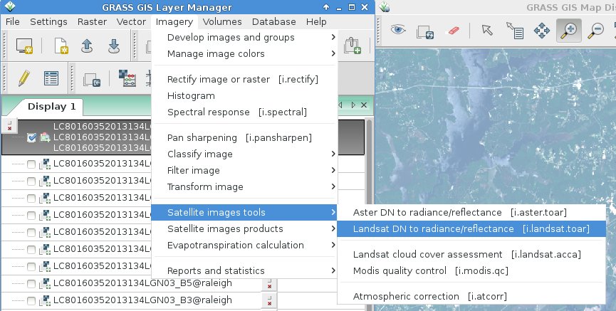
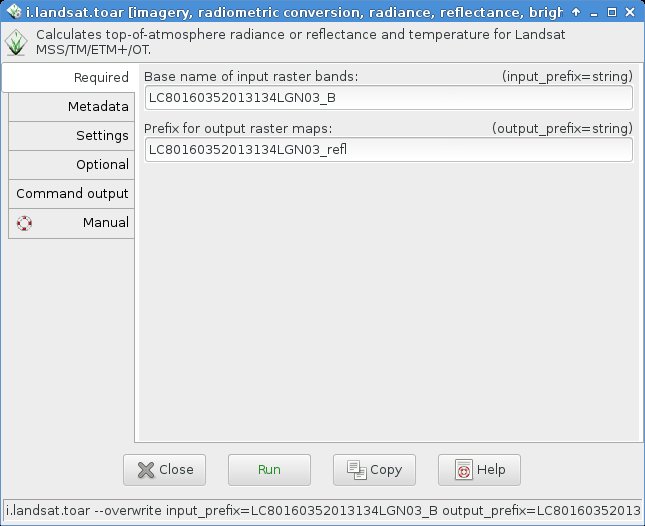
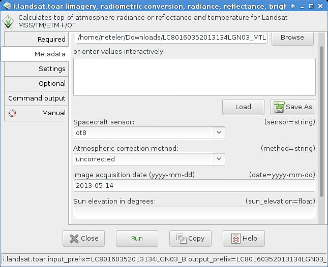
From Digital Numer (DN) to reflectance:
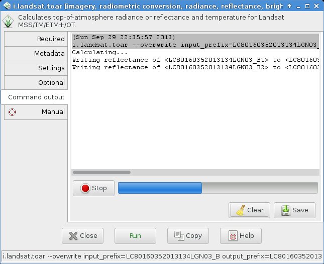
Before creating an RGB composite, it is important to convert the digital number data (DN) to reflectance (or optionally radiance). Otherwise the colors of a “natural” RGB composite do not look convincing but rather hazy (see background in the next screenshot). This conversion is easily done using the metadata file which is included in the data set with i.landsat.toar:
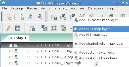
Now we are ready to create a nice RGB composite (hint 2015: i.landsat.rgb has been renamed to i.colors.enhance):
Select the bands to be visually combined:
… and voilà !
Applying the Landsat 8 Quality Assessment (QA) Band
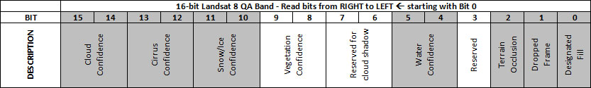
One of the bands of a Landsat 8 scene is named “BQA” which contains for each pixel a decimal value representing a bit-packed combination of surface, atmosphere, and sensor conditions found during the overpass. It can be used to judge the overall usefulness of a given pixel.
We can use this information to easily eliminate e.g. cloud contaminated pixels. In short, the QA concept is (cited here from the USGS page):
For the single bits (0, 1, 2, and 3):
0 = No, this condition does not exist
1 = Yes, this condition exists.
The double bits (4-5, 6-7, 8-9, 10-11, 12-13, and 14-15) represent levels of confidence that a condition exists:
00 = Algorithm did not determine the status of this condition
01 = Algorithm has low confidence that this condition exists (0-33 percent confidence)
10 = Algorithm has medium confidence that this condition exists (34-66 percent confidence)
11 = Algorithm has high confidence that this condition exists (67-100 percent confidence).
Detailed bit patterns (d: double bits; s: single bits):
d – Bit 15 = 0 = cloudy
d – Bit 14 = 0 = cloudy
d – Bit 13 = 0 = not a cirrus cloud
d – Bit 12 = 0 = not a cirrus cloud
d – Bit 11 = 0 = not snow/ice
d – Bit 10 = 0 = not snow/ice
d – Bit 9 = 0 = not populated
d – Bit 8 = 0 = not populated
d – Bit 7 = 0 = not populated
d – Bit 6 = 0 = not populated
d – Bit 5 = 0 = not water
d – Bit 4 = 0 = not water
s – Bit 3 = 0 = not populated
s – Bit 2 = 0 = not terrain occluded
s – Bit 1 = 0 = not a dropped frame
s – Bit 0 = 0 = not fill
Usage example 1: Creating a mask from a bitpattern
We can create a cloud mask (bit 15+14 are set) from this pattern:
cloud: 1100000000000000
Using the Python shell tab, we can easily convert this into the corresponding decimal number for r.mapcalc:
Welcome to wxGUI Interactive Python Shell 0.9.8

Type "help(grass)" for more GRASS scripting related information.
Type "AddLayer()" to add raster or vector to the layer tree.

Python 2.7.5 (default, Aug 22 2013, 09:31:58)
[GCC 4.8.1 20130603 (Red Hat 4.8.1-1)] on linux2
Type "help", "copyright", "credits" or "license" for more information.
>>> int(0b1100000000000000)
49152
Using this decimal value of 49152, we can create a cloud mask:
# set NULL for cloudy pixels, 1 elsewhere:
r.mapcalc "cloudmask = if(LC80160352013134LGN03_BQA == 49152, null(), 1 )"

# apply this mask
r.mask cloudmask
In our sample scene, there are only tiny clouds in the north-east, so no much to be seen. Some spurious cloud pixels are scattered over the scene, too, which could be eliminated (in case of false positives) or kept.
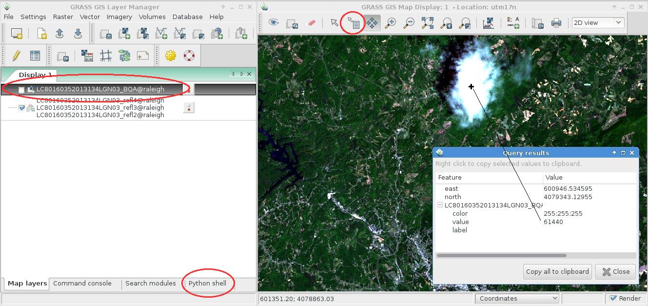
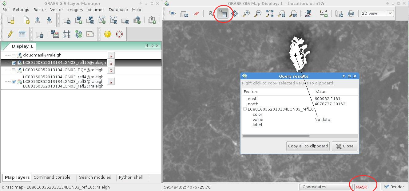
Usage example 2: Querying the Landsat 8 BQA map and retrieve the bitpattern
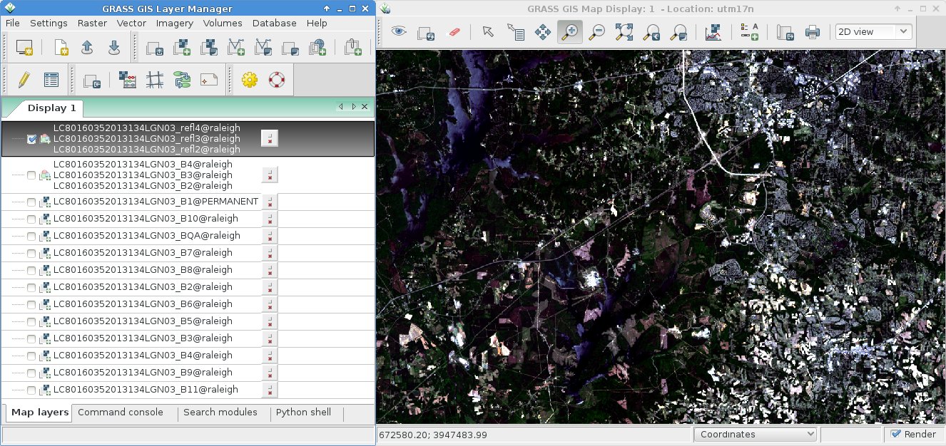
Perhaps you prefer to query the BQA map itself (overlay the previously created RGB composite and query the BSA map by selecting it in the Layer Manager). In our example, we query the BQA value of the cloud:
Using again the Python shell tab, we can easily convert the decimal number (used for r.mapcalc) into the corresponding binary representation to verify with the table values above.
Hence, bits 15,14,13, and 12 are set: cloudy and not a cirrus cloud. Looking at the RGB composite we tend to agree :-) Time to mask out the cloud!
wxGUI menu >> Raster >> Mask [r.mask]
Or use the command line, as shown already above:
# remove existing mask (if active)
r.mask -r

# set NULL for cloudy pixels, 1 elsewhere:
r.mapcalc "cloudmask = if(LC80160352013134LGN03_BQA == 61440, null(), 1 )" --o

# apply the new mask
r.mask cloudmask
The visual effect in the RGB composite is minimal since the cloud is white anyway (as NULL cells, too). However, it is relevant for real calculations such as NDVI (vegetation index) or thermal maps.
We observe dark pixels around the cloud originating from thin clouds. In a subsequent identification/mask step we may eliminate also those pixels with a subsequent filter.
https://neteler.org/wp-content/uploads/2024/01/wg_neteler_logo.png00Markushttps://neteler.org/wp-content/uploads/2024/01/wg_neteler_logo.pngMarkus2013-09-29 23:35:012023-11-20 16:46:07Processing Landsat 8 data in GRASS GIS 7: Import and visualization
The GRASS GIS community is delighted to present the outcome of the 4th Community Sprint that took place in a warm and sunny Prague, Czech Republic, from July 12 to July 18, 2013. The event happened after the Geoinformatics conference at the Czech Technical University in Prague. The Community Sprint was once more a creative gathering of both long-term and new developers, as well as users.
This meeting was held in the light of 30 YEARS OF GRASS GIS!
We wish to cordially thank the Department of Mapping and Cartography, Faculty of Civil Engineering, Czech Technical University in Prague for hosting and technical support. In particular, we gratefully acknowledge our association sponsors OSGeo and FOSSGIS e.V., and many individual donors: Peter Löwe, Andrea Borruso, Massimo Di Stefano, Alessandro Sarretta, Joshua Campbell, Andreas Neumann, Jon Eiriksson, Luca Casagrande, Karyn O Newcomb, Holger Naumann, Anne Ghisla, Helena Mitasova and Lubos Mitas, Dimitris Tamp, Mark Seibel, Markus Metz, and Tawny Gapinski. These financial contributions were used to cover costs such as meals and to help reducing travelling and accommodation expenses for participants with far arrival who came on own expenses.
Developers and users who joined the event came from various countries like Italy, Czech Republic, Slovak Republic, Poland, Sri Lanka/France, USA and Germany.
The Community Sprint focused on:
About GRASS GIS
The Geographic Resources Analysis Support System, commonly referred to as GRASS GIS, is an Open Source Geographic Information System providing powerful raster, vector and geospatial processing capabilities in a single integrated software suite. GRASS GIS includes tools for spatial modeling, visualization of raster and vector data, management and analysis of geospatial data, and the processing of satellite and aerial imagery. It also provides the capability to produce sophisticated presentation graphics and hardcopy maps. GRASS GIS has been translated into about twenty languages and supports a huge array of data formats. It is distributed freely under the terms of the GNU General Public License (GPL). GRASS GIS is an official project of the Open Source Geospatial Foundation (OSGeo).


")