ASTER GDEM 30m quality assessment
The recent publication of the ASTER GDEM (30m) is a great step towards a worldwide high resolution elevation model. I have done some test in the Southern Alps around Trento which is among the most complex terrains in Europe. The scope was to calculate a difference map to the local high resolution DEM.
The steps
1. Mosaicking and reprojection to UTM32/WGS84 of ASTER GDEM tiles of the area (using gdalwarp).
2. Import of the ASTER GDEM map into GRASS (r.in.gdal)
3. Creation of a difference map to the provincial DEM (r.mapcalc, r.colors)
4. Histogram and univariate statistics (d.histogram, r.univar)
The results
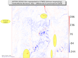
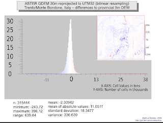
(click for higher resolution or download slides as PDF):
Comments
The hydrological pattern appears to coincide with the provincial rivers map. It can be seen that lakes weren’t masked during the ASTER DEM preparation, howver, these could be identified for many areas in the world with OpenStreetMap layers.
Despite spikes (including unexpected craters), the overall quality appears to be acceptable for this first version of ASTER GDEM – the standard deviation is 18m for the test area with outliers predominantely found in the areas of complex terrain rather than in the valley floors. A shift of -2.3m is also observed (reprojection artifact?).
It will be worth to check if SRTM data (90m) could help to identify and remove the spikes from the DEM. More hopefully in the near future…
Acknowledgments: ASTER GDEM is a product of METI and NASA.


 Follow
 Follow
I have done some very preliminary subjective checking. There are a lot of very prominent spikes in areas with both complex topography and frequent dense cloud cover. Island of Bioko (Equatorial Guinea) particularly affected. Other topographically complex areas with less cloud cover (eg Goma area eastern DRC) aparently very good with no spikes. Agree that SRTM data, not affected by cloud, could be used as a control
I did a little checking too: https://arrowsmith.blog.asu.edu/2009/07/27/looking-at-the-new-aster-30-m-dems-not-so-impressive-relative-to-srtm-90-m
Can you post a detailed tutorial how to import Aster DEM file (geotiff format) into GRASS, I’ve been using QGIS for a while but GRASS is totally new for me and seems quite complicated. Thanks in advance.
Not much complicated in fact using the new graphical interface of GRASS 6.4. See for an intro course (slides ast page attachment, file GRASS_geostat_landau_2011_intro.pdf). Page 28 shows the GeoTIFF import, but please read also the pages before.