MODIS (Terra/Aqua satellites) snow remote sensing


Software used: MRT and GRASS5.0, GRASS 6.1

MODIS/Terra snow product
Temporal Extent: 2000-06 (?) to present
MODIS snow cover 1km 8Aug2002 The Moderate Resolution Imaging Spectroradiometer (MODIS) is a 36-channel from visible to thermal-infrared sensor that was launched as part of the Earth Observing System (EOS) Terra payload on 18 December 1999. Snow maps at 500 m or 1 km resolution are produced. Daily and 8-day composite snow-cover maps, including daily snow albedo, daily and 8-day composite sea ice-cover maps, and sea ice-surface temperature maps are also produced. Daily and 8-day composite map products are available at 0.05° (or ~5.6km) resolution for climate modeling. All of the products are archived at the National Snow and Ice Data Center (NSIDC) in Boulder, CO.


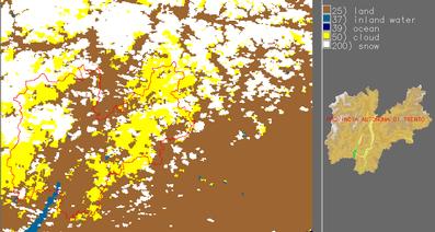
1 May 2001- maximum snow extend over 8 days
Part of Northern Italy as seen from MODIS/TERRA (MOD10A1) at 500m resolution (geocoded to Gauss-Boaga). Additionally a quality map is available which is not shown here.


General information on MODIS snow products

The MODIS snow product suite begins with a 500-m resolution, 2330-km swath snow-cover map which is then gridded to an integerized sinusoidal grid (ISIN). The sequence proceeds to the CMG product on a latitude/longitude (cylindrical equidistant projection). Each pixel of the CMG contains fraction of snow cover from 40  100%. The snow-mapping algorithms are automated which means that a consistent data set may be generated for long-term climate studies that require snow-cover information (cited from GSFC/NASA web page).

Earth Science Data Type (ESDT)

Product Level

Nominal Data Array Dimensions

Spatial Resolution

Temporal Resolution

Map Projection

MOD10_L2

L2

1354 km by 2000 km

500m

swath (scene)

None. (lat,lon referenced)

MOD10L2G

L2G

1200km by 1200km

500m

day of multiple coincident swaths

Sinusoidal

MOD10A1

L3

1200km by 1200km

500m

day

Sinusoidal

MOD10A2

L3

1200km by 1200km

500m

eight days

Sinusoidal

MOD10C1

L3

360° by 180° (global)

¼° by ¼°

day

Geographic

MOD10C2

L3

360° by 180° (global)

¼° by ¼°

eight days

Geographic

Table. 1: MODIS snow data products

MOD10A1 Daily Snow Cover

The daily level 3 snow product is the result of selecting an observation from the multiple observations mapped to a cell of the MOD10_L2G product. The daily snow product is a tile of data gridded in the Sinusoidal projection. Tiles are approximately 1200 x 1200 km in area. A single SDS of snow cover and a single SDS of QA data along with local and global attributes compose the data product file.

Algorithm Description:
The snow cover map for a day is constructed by examining the multiple observations acquired for a day that were mapped to cells of the grid by the L2G algorithm. A selection of best observation is made based on a ratio of percentage coverage of an observation in a cell to the distance of that observation from nadir. The observation that was closest to nadir with the greatest coverage in the cell is selected as the observation of the day to create the daily snow cover. The rationale was to select the observation least affected by off nadir viewing while maximizing coverage within a cell of the gridded projection. The relative view azimuth of the observation is also determined and if outside a set limit, a bit in the QA SDS is set to indicate that.
Results of the snow cover algorithm, a daily snow map of the region covered by the tile, are stored in the "Day_Tile_Snow_Cover" and per cell QA data for that snow map is stored in the "Snow_Spatial_QA" SDS. The snow cover data is stored as coded integer values, with values being the same as assigned in MOD10_L2.

Integer Value MODIS snow maps

Meaning

255

Fill Data--no data expected for pixel

254

Saturated MODIS sensor detector

200

Snow

100

Snow-Covered Lake Ice

50

Cloud Obscured

39

Ocean

37

Inland Water

25

Land--no snow detected

11

Darkness, terminator or polar

1

No Decision

0

Sensor Data Missing

Table 2: Legend of daily snow maps product

MOD10A2 Eight-day Snow Cover

An eight-day compositing period was chosen because that is the exact ground track repeat period of the Terra platform. Snow cover over eight days is mapped as maximum snow extent in one SDS (Scientific Data Set) and as a chronology of observations in the other SDS. Eight-day periods (Table 21) begin on the first day of the year and extend into the next year. The product can be produced with two to eight days of input. There may not always be eight days of input, because of various reasons, so the user should check the attributes to determine what days observations were obtained (cited from USGS web page).

Algorithm Description
:
The algorithm first checks that the input data, MOD10A1 files, are from the same eight-day period and orders them chronologically. The multiple days of observations for a cell are examined. If snow cover is found for any day then the cell in the "Maximum_Snow_Extent" SDS is labeled as snow. If no snow is found, but there is one  value that occurs more than once, that value is placed in the cell (e.g. water on five days, cloud on one, land on one, and night on one, would be labeled water). Otherwise, if mixed observations occur, e.g. land and cloud over multiple days, the algorithm is biased to clear views in the period and will label a cell with what was observable. The logic minimizes cloud cover extent in that a cell would need to be cloud obscured for all days of observation to be labeled as cloud. If all the observations for a cell are analyzed but a result is not reached then that cell is labeled as no decision. A chronology of snow occurrence is recorded in the "Eight Day Snow Cover" SDS. On days that snow is found the bit corresponding to that day, eight-days across the byte from right to left, is set to on. An eight-day compositing period was chosen because that is the exact ground track repeat period of the Terra platform. Snow cover over eight days is mapped as maximum snow extent in one SDS and as a chronology of observations in the other SDS. Eight-day periods (Table 21) begin on the first day of the year and extend into the next year. The product can be produced with two to eight days of input. There may not always be eight days of input, because of various reasons, so the user should check the attributes to determine what days observations were obtained.
 The algorithm will generate a product for any number of days from two to eight in the eight-day period. Sometimes all eight days of input may not be available due to data acquisition or production problems. The algorithm was designed to run will with fewer than eight days so that the data acquired could be processed even if one to six days of data is unavailable. Days used as input are identified in the global attributes.

Two SDSs (Scientific Data Sets) exist in the product, "Maximum_Snow_Extent" and "Eight_Day_Snow_Cover". The maximum snow extent for the period is contained in the "Maximum_Snow_Extent" SDS that depicts where snow was observed on one or more days in the period. An 8-day composited snow cover product will be generated by compositing successive days of snow cover products. This will yield maximum snow extent for the 8-day period. If a pixel were snow covered on any orbit during that period, then that pixel will be mapped as snow covered even if it were snow-free on all of the other orbits during the 8-day period. Other coverage and persistence statistics will also be included to assist analysis of the data product. Summary statistics and quality assurance (QA) data will be included as metadata.
Legend: 200=snow, 100=lake ice, 50=cloud, 39=ocean, 37=inland water, 25=land, 11=night, 4=erroneous data, 3=beyond 45deg scan, 1=missing data, 0=no decision

Days in the eight-day period when snow was observed are shown in the "Eight_Day_Snow_Cover" SDS. Input files are ordered chronologically in the algorithm and for days on which snow was observed a bit in the byte is set to on. Across a byte the days are ordered from right to left, bit 0 corresponds to day 1 of the eight-day period, bit 1 corresponds to day 2 of the eight-day period, bit 7 corresponds to day 8 of the eight-day period. If a bit setting of off could mean that data for that day was missing or that cloud was observed or that snow was not observed.
Legend: day1 in bit0...day8 in bit7, on means snow, off means not


Summary

We can process and geocode (to Gauss-Boaga and/or Bolzano projection) following MODIS snow related products:

Additionally there are ASTER/TERRA data available: 15m/30m/90m resolution (similar/better than LANDSAT-7). The satellite only take imagery on demand. Some images are available for Bolzano, but never a full coverage at one time. For winter 2000/2001 and winter 2001/2002 80% of the area are covered with 1 or two image sets.


Links:
Markus Neteler 8/2002, 2005
Back to MPA Remote Sensing page